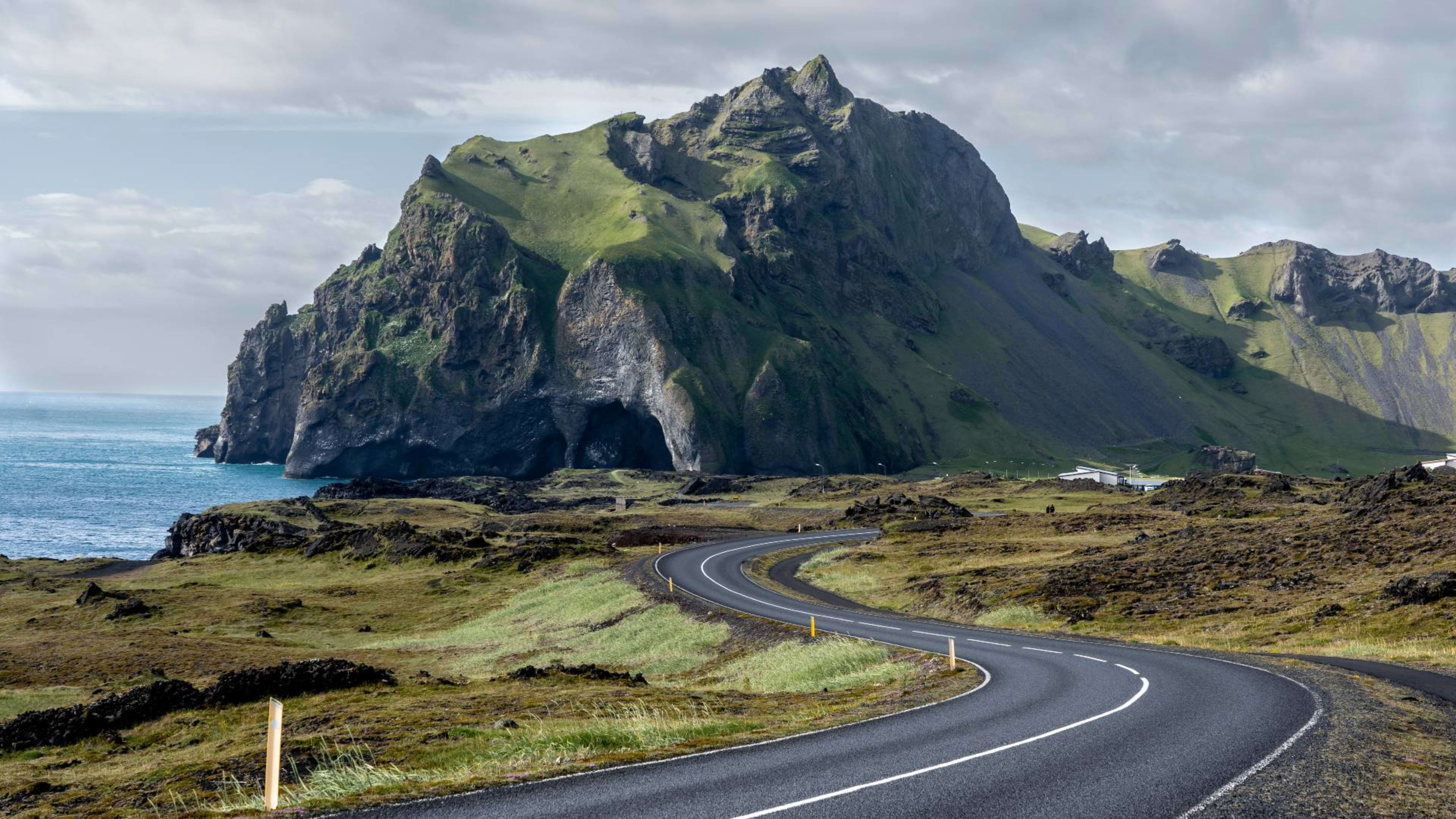
Iceland's south coast runs east from Reykjavík along Route 1 for around 380 kilometres, covering a concentration of landscapes found nowhere else in the country.
Within a day's drive of the capital you have powerful waterfalls, black volcanic beaches, the edge of Europe's largest glacier, and a lagoon filled with drifting icebergs.
This guide covers the main stops along the route, what to expect at each one, and a few places nearby that are worth adding to your itinerary.
- Discover South Iceland's top natural wonders with these south coast tour packages.
Should you visit Iceland’s south coast?
Yes. There are so many unmissable things to see in South Iceland, and it’s an adventure you won't want to miss.
If you’re a nature enthusiast, an adventure seeker, or simply just love stunning landscapes, the south coast has something for you.
Top things to do in South Iceland
Here are some of the best activities you could do on Iceland’s south coast:
- Chase majestic waterfalls
- Stroll along black sand beaches
- Hike on glaciers or through canyons
- Sail across blue waters in search of whales
- Go on an ice caving expedition
- Visit charming coastal villages
- Kayak or sail on a glacier lagoon
- Go on a road trip
- Unwind in soothing hot springs
- Indulge in local food
- Check out more activities and day trips you could add to your Iceland trip.
Best things to see on the south coast of Iceland
Discover the unmatched beauty of Iceland's south coast, where landscapes, waterfalls, and lava formations will leave you speechless.
Add some of these locations to your travel itinerary when you're planning a trip to Iceland, for a getaway to remember.
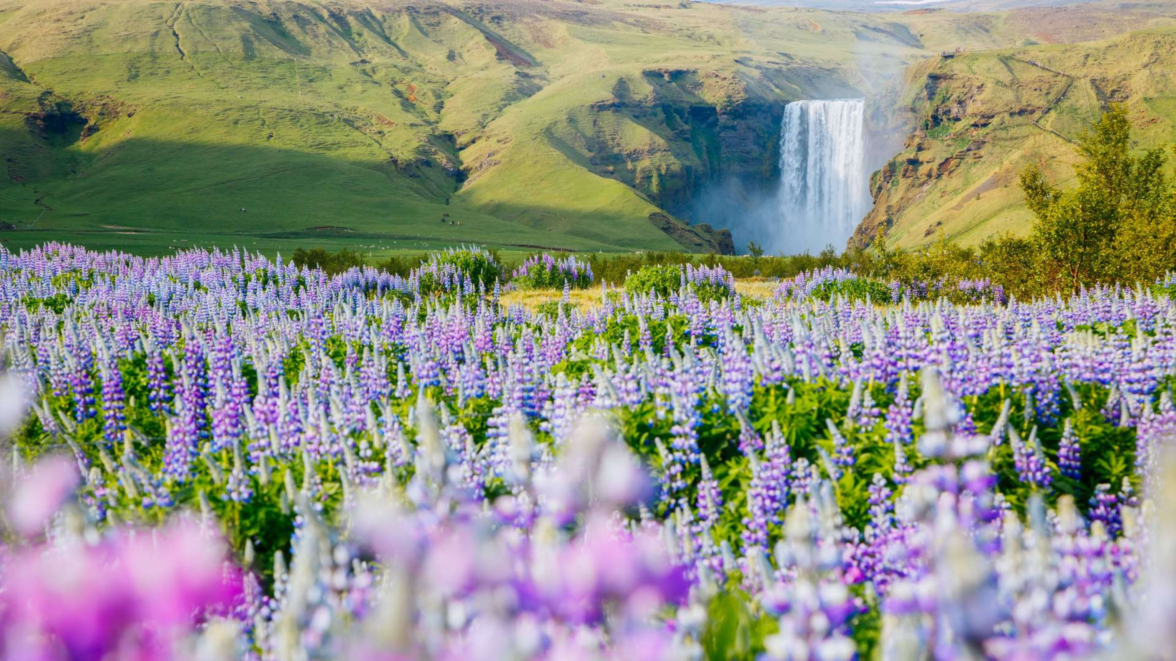
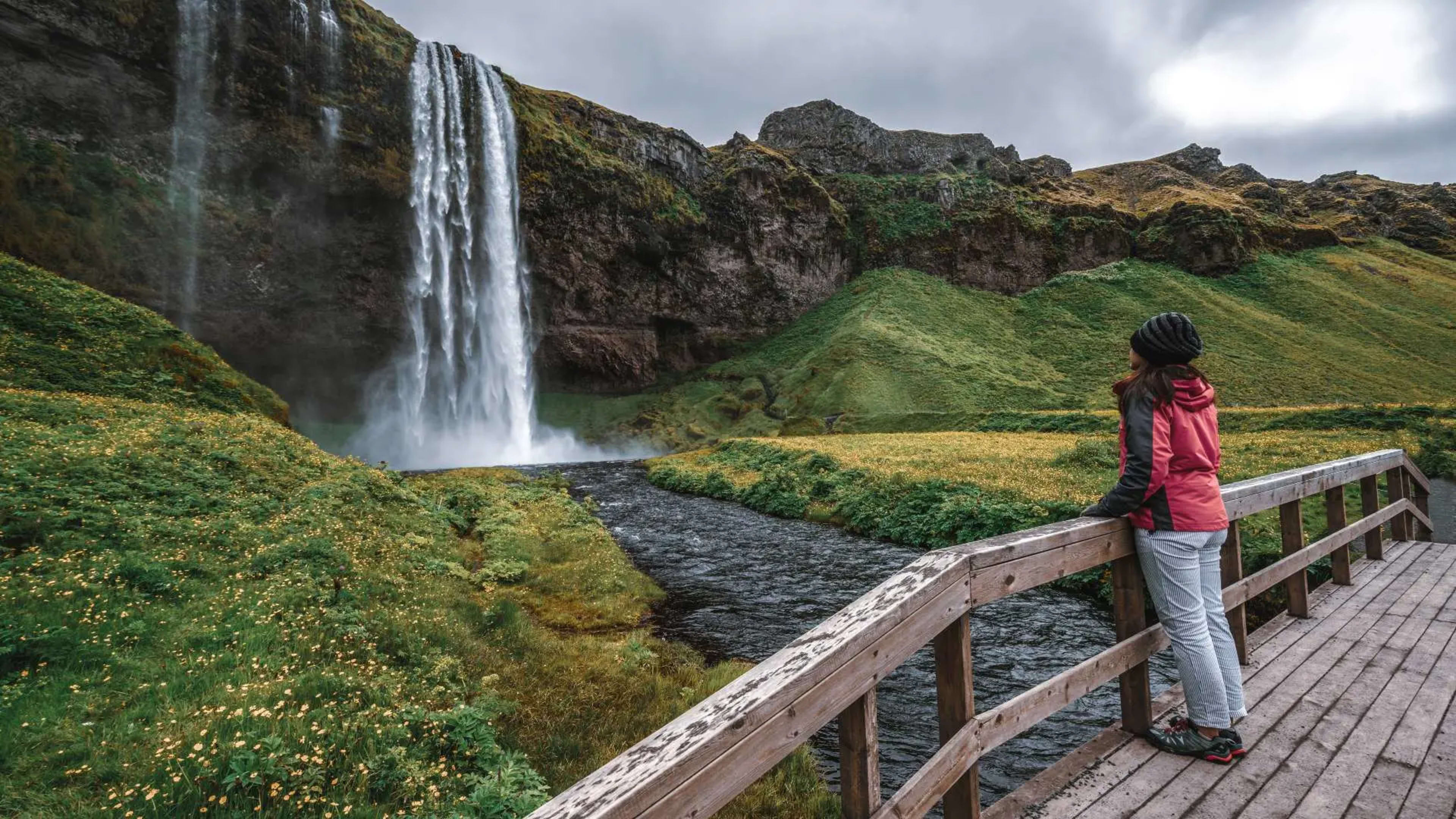
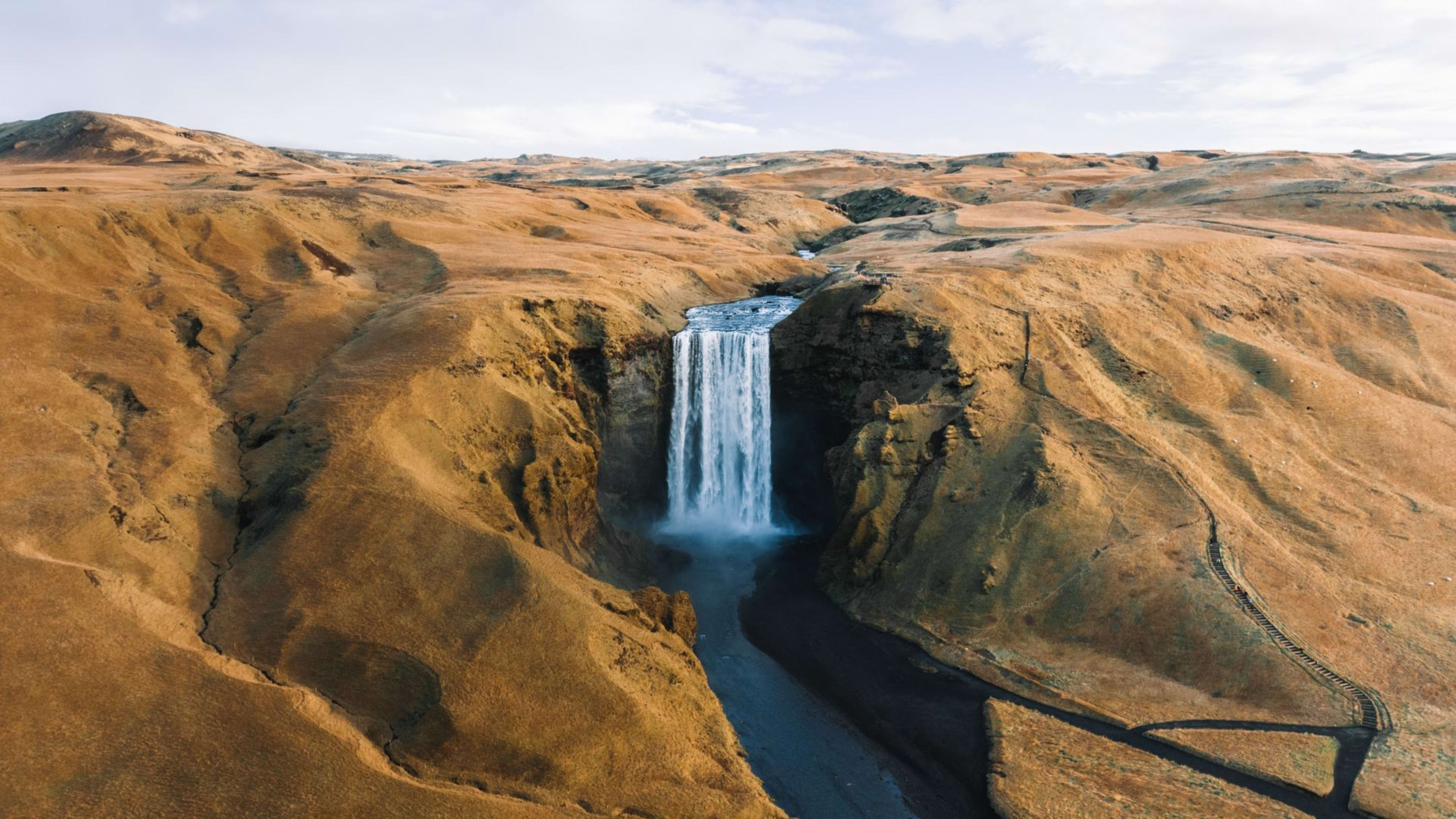
1. Skógafoss and Seljalandsfoss waterfalls
Both waterfalls sit within a short drive of each other on the western end of the south coast, roughly two hours from Reykjavík.
Seljalandsfoss drops about 60 metres from a former sea cliff into a pool below. A path leads behind the curtain of water, giving you a view back through the falls. Wear waterproof layers, as you will get wet. The path closes in icy conditions.
Skógafoss, a few kilometres further east, is wider and more powerful. At 60 metres high and 25 metres across, the volume of water is enough to generate a persistent mist. On clear days a rainbow is often visible in the spray. Steps beside the falls lead to a viewing platform at the top, with the Skógar river and surrounding hillside laid out below.
- Stay in Reykjavík and explore nearby attractions on a multi-day tour.
- Related: Best waterfalls in Iceland & where to find them.
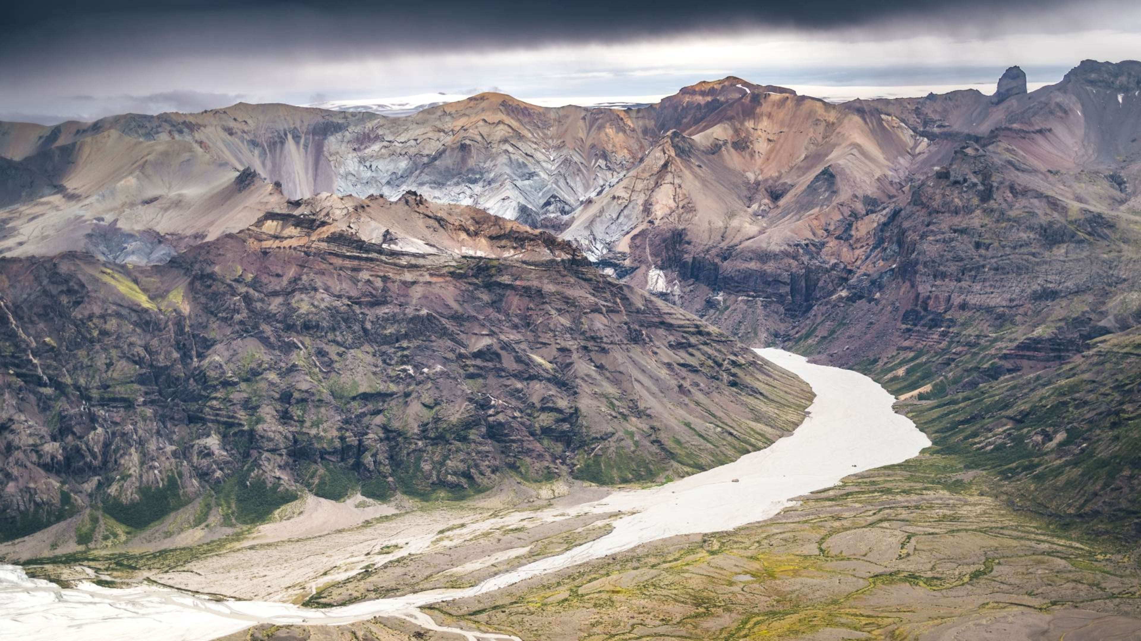
2. Vatnajökull National Park and glacier

Vatnajökull is Europe's largest glacier by volume, covering around 8 per cent of Iceland's total land area. The national park that surrounds it extends north and east, taking in Skaftafell to the south-west and Jökulsárgljúfur canyon in the north.
On the south coast, the glacier's outlet tongues reach down toward the Ring Road in several places. Glacier hikes operate from Skaftafell and from outfitters near Jökulsárlón throughout the year, though conditions vary by season. Ice cave tours inside the glacier operate primarily from October through March, when the ice is stable enough to enter safely.
- Discover the frosty side of Iceland on a tour of ice caves.
3. Jökulsárlón glacier lagoon

Jökulsárlón sits at the eastern end of the south coast, roughly 380 kilometres from Reykjavík, where the Breiðamerkurjökull outlet glacier meets the sea. Icebergs calve from the glacier face and drift slowly across the lagoon toward the Atlantic, ranging from car-sized fragments to formations several storeys high. Some carry dark bands of volcanic ash compressed within the ice over centuries.
The lagoon is free to visit, with a large car park directly on Route 1. Between May and October, licensed operators run boat tours. Amphibian vessels carry larger groups for around 30 to 40 minutes, while Zodiac tours operate with smaller groups on open boats and get closer to the ice faces. Seals are regularly seen in and around the lagoon year-round.
- See icebergs, glaciers, and more on a guided group tour of Iceland.
- Related: Your guide to the Jökulsárlón glacier lagoon.
4. Diamond Beach (Fellsfjara)

Directly across Route 1 from Jökulsárlón, Breiðamerkursandur, commonly known as Diamond Beach, is where icebergs that drift through the lagoon's outlet channel wash up on black volcanic sand before melting. The contrast of white and blue ice against the dark beach changes with every tide, as new pieces arrive and existing ones melt or break apart. It is a short walk from the road and accessible throughout the year.
- See all of these iconic sights and more on an Iceland Ring Road tour.
- Related: Your complete guide to Diamond Beach.
5. Reykjadalur valley
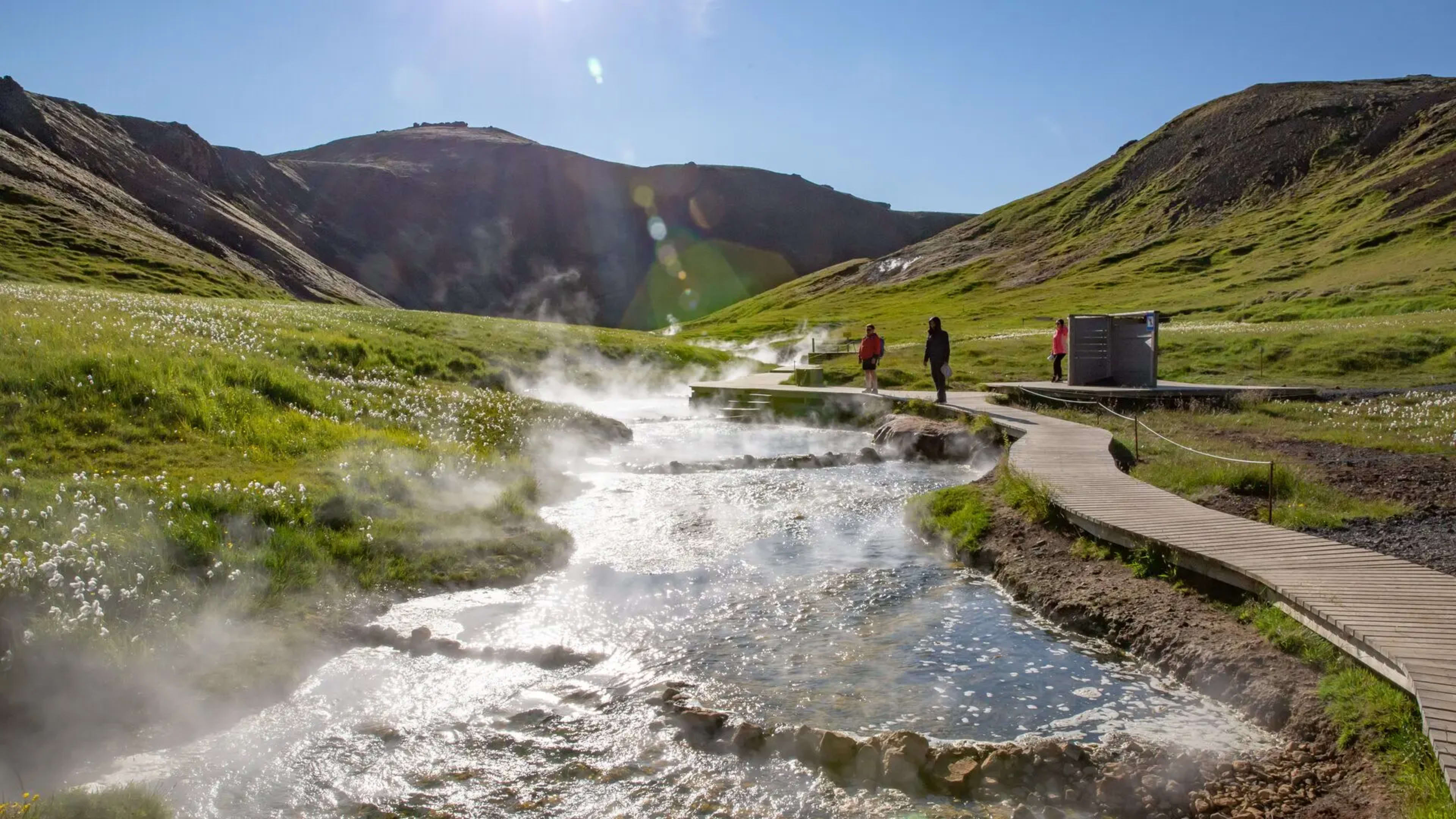
A short detour inland from Hveragerði, Reykjadalur is a geothermally active valley where a warm river runs through moss-covered hillside. The hike from the car park takes around 45 minutes each way on a well-marked trail. The river temperature varies along its length, with warmer water further upstream. The area is set up for bathing, with changing facilities at the trailhead. Bring a swimsuit and a towel.
- Dive into these Iceland vacation ideas.
- Related: Your guide to Iceland’s hot springs and geothermal pools.
6. Reynisfjara black sand beach

Reynisfjara is Iceland's most visited black sand beach, sitting just west of Vík. The beach is formed from basalt broken down by wave action over centuries, and the same volcanic geology gives rise to the distinctive hexagonal basalt columns stacked against the cliff face at the eastern end.
Offshore, the Reynisdrangar sea stacks rise from the water. According to Icelandic folklore they are trolls turned to stone while attempting to drag a ship ashore.
The waves at Reynisfjara are dangerous. Sneaker waves arrive without warning and reach well beyond where previous waves have broken, and have caused fatalities here. Stay well back from the waterline and follow the warning signs on the beach.
- Explore at your own pace on a self-drive tour of Iceland
- Ensure your Iceland trip goes smoothly with these health & safety tips.
7. Vík í Mýrdal village

Vík is the southernmost village in Iceland and the main service stop on the south coast between Reykjavík and Skaftafell. It has a petrol station, a supermarket, several restaurants and cafes, and accommodation. The red-roofed church above the village is one of the most recognisable landmarks on the coast.
Mýrdalsjökull glacier sits directly north of the village, covering the Katla volcano beneath it. Katla is one of Iceland's more closely monitored volcanoes, with an eruption considered overdue by geological standards.
- Related: Best towns & cities to visit in Iceland.
8. Fjaðrárgljúfur canyon

East of Kirkjubæjarklaustur, Fjaðrárgljúfur is a two-kilometre canyon carved by glacial meltwater over thousands of years. The walls reach up to 100 metres and are covered in moss and vegetation fed by the river below. A walking path follows the eastern rim of the canyon, with viewpoints at intervals along the route. The full walk to the head of the canyon and back takes around 45 minutes to an hour.
The site has a visitor platform and parking area signposted off Route 1. Access can be limited during high visitor seasons to protect the surrounding vegetation.
- Start your adventure with these summer vacations in Iceland.
- Related: Your guide to Iceland in spring.
9. Raufarhólshellir lava tunnel

- Visit Raufarhólshellir & other volcanic sights on an Iceland volcano tour.
- Related: Your guide to ice caves and lava caves in Iceland.
10. Skaftafell
Skaftafell occupies the south-western edge of Vatnajökull National Park, roughly 327 kilometres east of Reykjavík. The area has a well-developed trail network ranging from short walks to full-day hikes, a visitor centre with information on the park, and year-round glacier access via guided tours onto Svínafellsjökull.
The Svartifoss waterfall, about a 45-minute walk from the car park, is one of the most visited points in the area. Its basalt column backdrop makes it one of the more photographed spots in the national park. Rangers are based at the visitor centre and guided glacier walks depart daily in summer.
- Get fully immersed in nature on an active tour of Iceland.
11. Eldhraun lava field

Between Vík and Kirkjubæjarklaustur, Eldhraun is one of the largest lava fields in the world, produced by the Lakagígar eruption of 1783 to 1784, one of the most significant volcanic events in recorded history. The entire surface is now covered in thick moss, giving the landscape an almost uniform pale green. The lava field is visible from Route 1, with a designated parking area where you can stop.
The moss layer at Eldhraun is extremely fragile. It grows only a few millimetres per year and can take centuries to recover from disturbance. Stay on the marked path and do not walk on the moss.
- Let your knowledgeable driver-guide lead the way on a privately guided tour of Iceland.
- Related: Your ultimate guide to driving Iceland’s Ring Road.
Other places you shouldn’t miss near the south coast
1. Golden Circle
The Golden Circle is a natural addition to any south coast itinerary. Þingvellir, Geysir, and Gullfoss are all within easy reach of Reykjavík and are often combined with the first day or two of a south coast trip. See our Golden Circle guide for details.
- See these top natural wonders on a Golden Circle tour.
- Related: Your complete guide to the Golden Circle route.
2. The Blue Lagoon
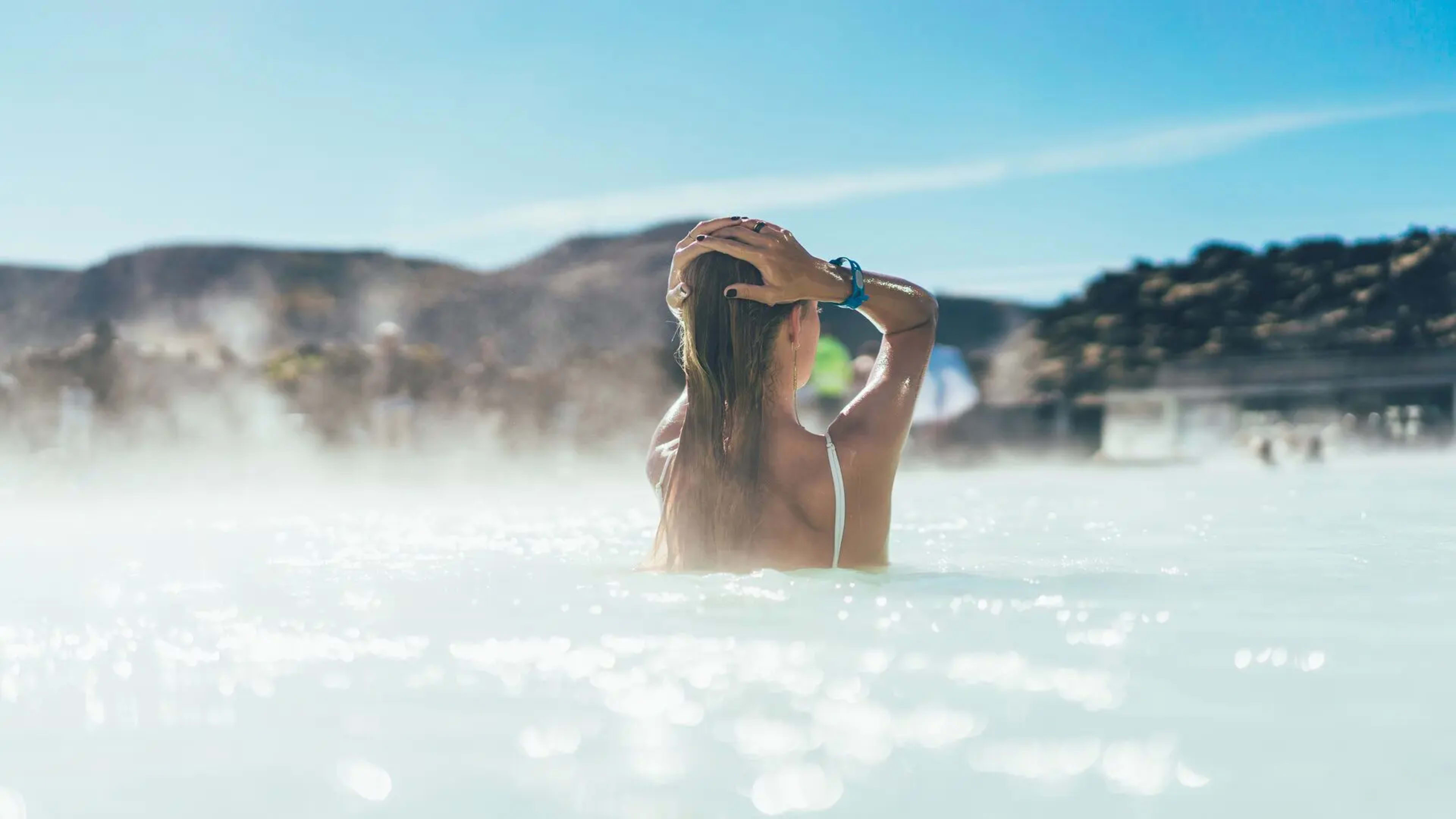
The Blue Lagoon sits on the Reykjanes peninsula between Keflavíkurflugvöllur and Reykjavík, making it a natural stop on arrival or departure day. Advance booking is required. See our Blue Lagoon page for current ticket information.
- Related: Your guide to the Blue Lagoon.
3. Westman Islands
The Westman Islands (Vestmannaeyjar) lie off the south coast and are reached by ferry from Landeyjahöfn, roughly a 35-minute crossing. Heimaey is the only inhabited island and has the Eldheimar museum covering the 1973 eruption that buried part of the town. The islands are also one of the largest puffin nesting grounds in the world, most active between May and August.
- Related: Best places to see puffins in Iceland.
Planning your trip to Iceland’s south coast
Iceland Tours runs self-drive, guided group, and multi-day packages that cover the south coast as part of a wider Iceland itinerary. All packages include accommodation, transport, and daily breakfast. Browse south coast tour packages or contact our Reykjavík-based team if you have questions about building your itinerary.
FAQs about Iceland's South Coast
Planning a trip to Iceland's south coast? Here are answers to the questions we hear most often.
The drive from Reykjavík to Jökulsárlón along Route 1 takes around five hours without stops. With time at the main attractions, most visitors allow two to three days to cover the south coast properly. A single long day is possible but leaves little time at each stop.
Jökulsárlón glacier lagoon and Reynisfjara black sand beach are the most visited stops on the route. Seljalandsfoss and Skógafoss are also among the most photographed locations in Iceland and are within two hours of Reykjavík.
Yes. Route 1 along the south coast is maintained year-round and the main attractions are open in all seasons. Ice cave tours inside Vatnajökull operate primarily from October through March. Dyrhólaey closes between 15 May and 23 June for nesting season but is otherwise open. Boat tours on Jökulsárlón run from May to October only.
The western end of the south coast, including Seljalandsfoss and Skógafoss, is around 150 kilometres from Reykjavík, roughly two hours by car. Jökulsárlón at the far eastern end is approximately 380 kilometres, around five hours without stops.
No. Route 1 along the south coast is paved and suitable for a standard two-wheel drive vehicle year-round. A 4x4 is only required if you plan to drive on F-roads, which are unpaved mountain tracks not on the main south coast route.
The western section, including Seljalandsfoss, Skógafoss, and Reynisfjara, is manageable as a day trip. Reaching Jökulsárlón and Diamond Beach in a single day from Reykjavík leaves very little time at either location and involves around ten hours of driving. An overnight stop is recommended if you want to cover the full route.