Iceland's geology makes for varied and often striking hiking terrain: lava fields, basalt canyons, glacier edges, and coastal cliffs are all accessible on day walks.
This guide covers 20 of the best day hikes across every region of the country, from routes near Reykjavík to trails in the Westfjords and East Iceland, with distances, elevation, and practical notes for each.
- Plan an active trip in the Land of Fire and Ice with these adventure tours in Iceland.
Reykjavík and the Reykjanes peninsula
In Iceland’s capital, Reykjavík, opportunities for hiking adventures are right on your doorstep. Here are the 2 most popular options.
- Base yourself in the city and explore the surrounding area with multi-day tours from Reykjavík.
1. Mount Esja (Reykjavík)

Distance: 8 km (5 mi) there and back
Elevation gain: 731m (2400 ft)
Mount Esja is a flat-topped mountain that looms over Reykjavík. From its peak at 914 metres (2,998 feet) above sea level, you get wide views over the city and coast.
Head to the top on one of the many well-marked paths. The routes are graded by difficulty, so pick the one that suits your fitness level. Whichever you choose, be aware that the mountain can be exposed to the elements, especially at the summit.
200 meters (656 feet) from the top, the path becomes a little more challenging. Feel free to stop at this point if you want. You’ll have done a great job to make it this far.
2. Fagradalsfjall (Reykjanes peninsula)
Distance: Different options from 8 km (5 mi) to 20 km (12 mi) there & back
Elevation gain: Up to 400m (1312 ft) ascent
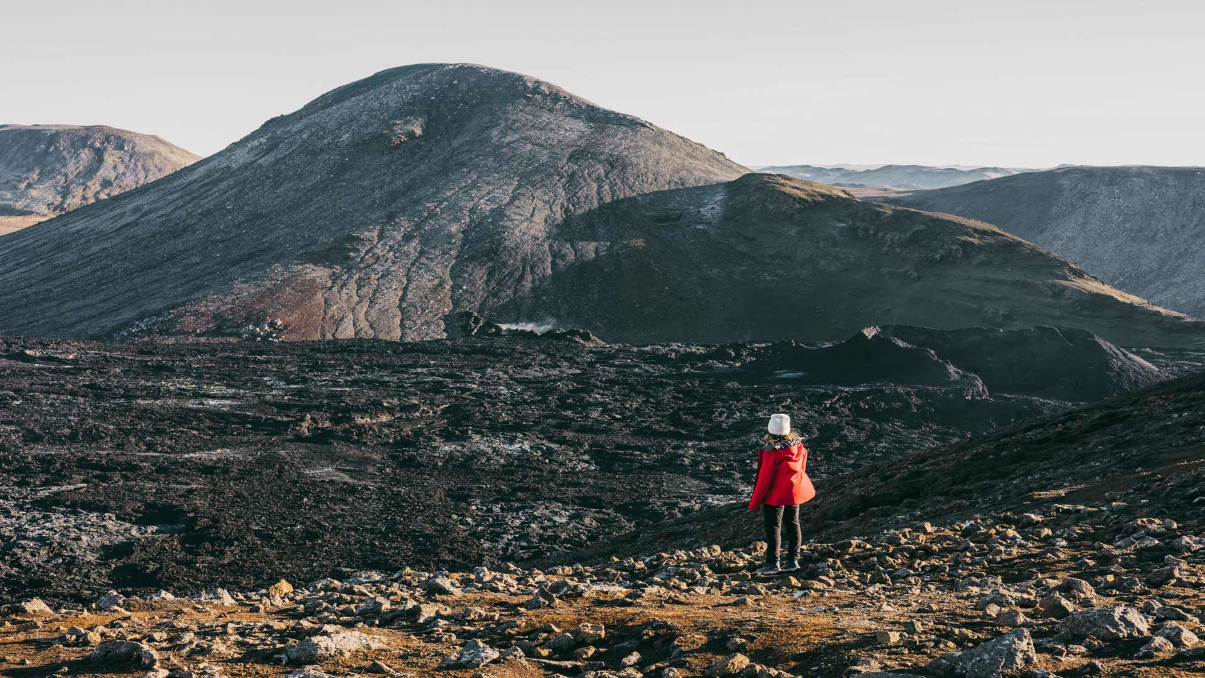
To the southwest of Reykjavík, the Reykjanes peninsula has been one of Iceland's most volcanically active areas since 2021, with eruptions at Fagradalsfjall in 2021 and 2022, Litli-Hrútur in 2023, and a series of eruptions at the Sundhnúkur crater row through 2024 and 2025. The result is an extensive and still-evolving lava landscape with marked hiking trails from the P1 parking area near Fagradalsfjall.
Two main trail options run from P1. Trail A leads to the Geldingadalur and Meradalir lava fields from the 2021 and 2022 eruptions, covering around 6 to 8 km one way. Trail B heads toward the Sundhnúkur crater row and the more recent lava fields, with viewpoints at roughly 5 and 6 km from the parking area. Both involve uneven, rocky ground and some steep sections.
Trail access and conditions can change quickly, particularly if new volcanic activity begins. Always check safetravel.is before you go.
The Golden Circle
The Golden Circle is known as one of the most beautiful and sought-out areas in Iceland. Get off the beaten track with one of these day hikes.
- Tour the region with these Golden Circle packages.
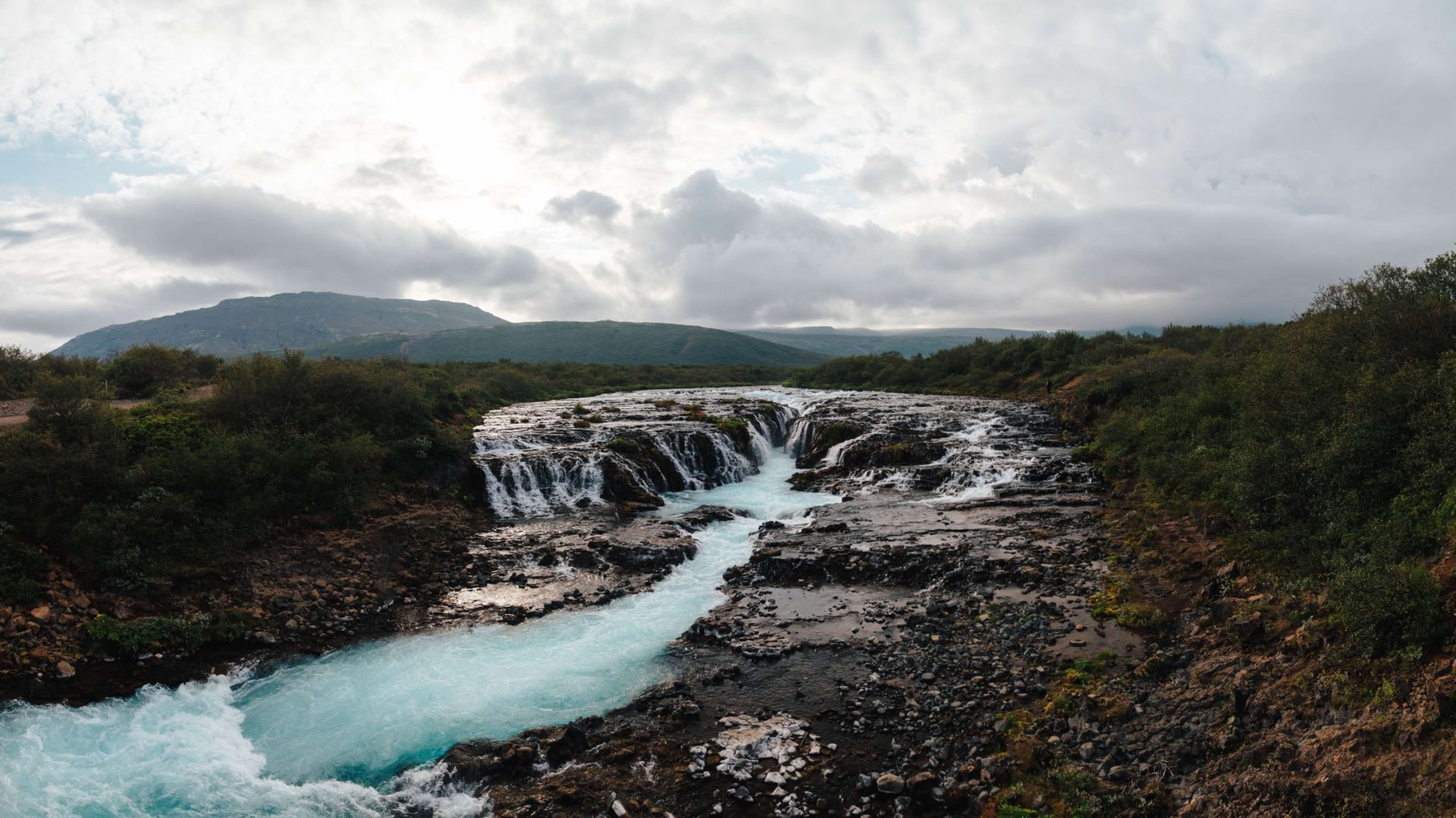
3. Brúarfoss (Geysir area)
Distance: 7.7 km (4 mi) there and back
Elevation gain: Flat
Brúarfoss is one of the more distinctive waterfalls on the Golden Circle route. You’ll see its bright blue waters flowing down from the Langjökull glacier and cascading over a series of gentle ledges.
To reach the waterfall, hike from the parking lot at Brúará bridge on road 37. The path is flat and even, but it can sometimes get a little muddy. In winter, if it snows, the route can be inaccessible.
Along the path, you’ll follow the river Brúará, passing other waterfalls such as Miðfoss and Hlauptungufoss.
4. Reykjadalur (Hveragerði)

Distance to Reykjadalur swim spot: 7 km (4 mi) there and back
Complete loop via Ölkelduhnúkur: 11 km (7 mi)
Elevation gain: 340m (1115 ft)
Reykjadalur is a popular hike in the valley next to Hveragerði where the river runs with naturally warm water, making it a practical stop for wild swimming. That means it doesn’t just offer a spectacular hike, it’s also a top spot for wild swimming.
The easy hike takes you 3.5 km (2 mi) up the valley where you’ll find a small area to get changed. Here, you can get out of your hiking boots, put on your swimsuit, and relax in the warm stream and pools.
If you want to stretch your legs further, continue on the path to the dramatic Klambragil canyon. From there, you can climb to the top of the rounded mountain, Ölkelduhnúkur, for views over Reykjadalur valley.
- Visit hot springs on a summer tour of Iceland.
- Related: Iceland hot springs and geothermal pools – Your guide.
South Iceland
Running from Reykjanes peninsula in the west to the Vatnajökull National Park in the east, South Iceland is full of natural wonders. Here are 3 top hikes in the area.
5. Eldfell (Vestmannaeyjabær)

Distance: 3.4 km (2 mi) there and back
Elevation gain: 120m (394 ft)
Back in 1973, the Eldfell volcano erupted on the island of Heimaey, part of the Westman Islands group. Half a century later, you can still see the form it left behind.
There are 3 routes up this volcano, which all start from the parking lot to the southeast of Vestmannaeyjabær village. Each path takes you to Eldfell’s highest point and Páskahellir, a rock formation created during the eruption.
With sea views and a fascinating insight into Iceland’s volcanoes, it’s a rewarding route, manageable for the whole family.
- Discover South Iceland's best hikes on a south coast tour.
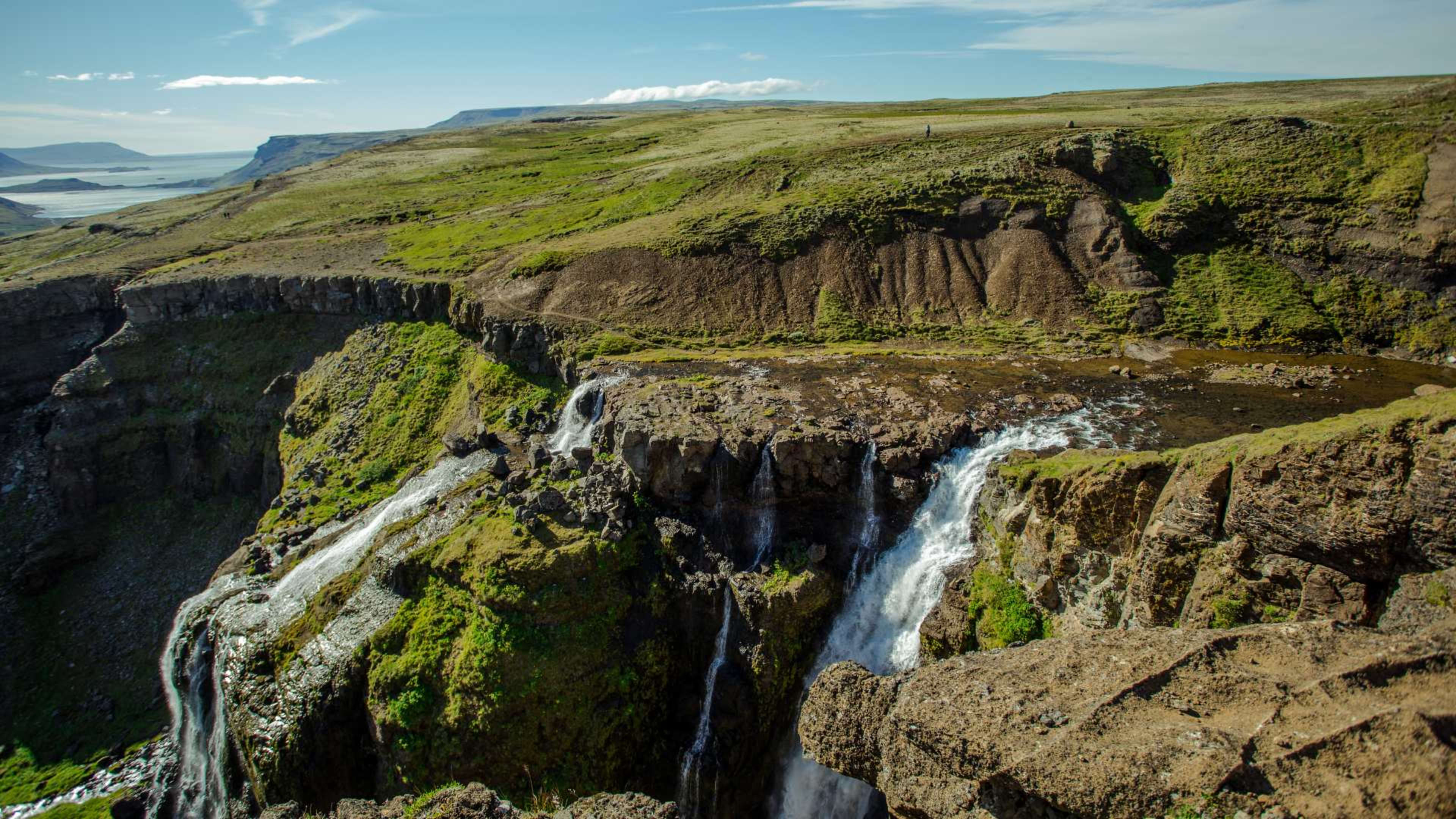
6. Glacier trail (Skaftafell)
Distance: 4.5 km (2 mi) there and back
Elevation gain: 82m (270 ft)
Skaftafell is a wilderness area in the heart of the larger Vatnajökull National Park. The scenery is lush and wild, with many footpaths for you to explore.
A favorite route is the Glacier trail, or Jökulslóð, as it’s known in Icelandic. It’s a fantastic way to see the impact of retreating glaciers on the landscape. The trail takes you just over 4 km (2 mi) from the Skaftafell Visitor Centre, on paved and gravel paths.
You’ll discover the landforms, such as kettle holes, created by the melting ice of a retreating glacier. At the furthest point of the walk, you’ll catch a glimpse of the Skaftafellsjökull glacier, which has retreated hundreds of meters.
7. Svartifoss (Skaftafell)

Distance: 6 km (4 mi) loop
Elevation gain: 250m (820 ft)
Svartifoss is a dramatic waterfall surrounded by towering columns of basalt rock. Like the Glacier trail, the route to Svartifoss starts at the Skaftafell Visitor Centre. The path is wide and easy to follow, with a steady climb most of the way.
After passing through a campground, the viewpoint over Svartifoss will be your first stop. Then, continue on the path down into the ravine, over a footbridge, and up the rocks on the other side. Loop back to the visitor center passing another viewpoint, Sjónarnípa, and the turf house at Sel.
8. Dyrhólaey (South Iceland)
Distance: 4 km (2.5 mi) loop Elevation gain: 110m (360 ft)
Dyrhólaey is a small peninsula jutting out from Iceland's south coast, about 6 km west of Vík. Its defining feature is a large basalt sea arch, visible from both the lower and upper viewpoints on the peninsula. The loop trail between those two points takes you along the clifftops, with views across Reynisfjara and the black sand beaches stretching east toward Vík.
The walk is straightforward and manageable for most fitness levels, though the upper section can be exposed and windy. In summer, the clifftops are home to nesting puffins. Note that the reserve is closed between 15 May and 23 June to protect nesting birds, so plan your visit outside that window.
- Related: South Iceland: what to see and do.
9. Skógafoss and the Fimmvörðuháls trail (South Iceland)
Distance: Approximately 16 km (10 mi) there and back to the upper valley Elevation gain: 600m (1970 ft)
The trail from Skógafoss up the Skógá river valley is one of the most rewarding day hikes on the south coast. It begins at the top of the waterfall, reached by climbing a staircase alongside the falls, and then follows the river upstream past more than 20 waterfalls of varying sizes through a deep, lush gorge.
As the valley opens out and the vegetation thins, the landscape shifts into a more barren highland terrain with views across toward Eyjafjallajökull and Mýrdalsjökull. Turning back at this point makes for a 4 to 6 hour return hike. Those with more time and experience can continue to the Fimmvörðuháls pass, where the trail crosses the 2010 Eyjafjallajökull lava field before descending into Þórsmörk -- a full crossing of 25 km one way best done with transport arranged at both ends, or as an overnight with a stop at Baldvinsskáli hut.
Weather at the pass can deteriorate quickly even in summer. Only attempt the full crossing if you are well prepared and conditions are good.
West Iceland
Home to fjords, mountains, and the magical landscapes of the Snæfellsnes Peninsula, West Iceland is a thrillingly diverse region. Hike these 3 trails to explore all of its treasures.
10. Glymur waterfall (Hvalfjörður)
Distance: 7 km (4 mi) there and back
Elevation gain: 400m (1312 ft)
Glymur may be Iceland’s second tallest waterfall, but it’s by far the tallest that can be reached on foot. Here, you can see the waters of the river Botnsá tumble 198 meters (650 feet) into a canyon flanked by steep cliffs.
One way to see the waterfall is on an out-and-back hike. Start the route on the east side of the Botnsá river and return the same way you came.
Be aware that you need to cross the river along the way. In summer, you’ll find a log that you can use, with ropes to hold onto. In winter, the log won’t be in place, meaning the waterfall itself won’t be accessible.
11. Eldborg (Snæfellsnes)
Distance: 6.5 km (4 mi) there and back
Elevation gain: 60m (200 ft)
The Snæfellsnes peninsula has a varied landscape of glaciers, volcanoes, and black sand beaches.
One popular day hike on the peninsula takes you to Eldborg, a volcanic crater that rises steeply out of the surrounding lava fields. The route follows a clear path from Snorrastaðir to the south, with views of the Snæfellsjökull glacier and the mountains of the peninsula opening up as you climb.
The easiest approach is from Snorrastaðir to the south of Eldborg. But be aware that the steps that take you to the top of the crater can be a little uneven.
- Related: Snæfellsnes peninsula – Ultimate guide.
12. Arnarstapi to Hellnar (Snæfellsnes)

Distance: 6 km (4 mi) there and back
Elevation gain: 80m (262 ft)
For one of the top coastal walks in Iceland, head to the western tip of the Snæfellsnes peninsula. Here, you’ll find cute fishing villages, diverse rock formations, and lots of sealife.
Start at the harbor of the small settlement of Arnarstapi and follow the path along the cliffs to the south. Pass a natural stone bridge, and don’t forget to stop at the Arnarstapi viewpoint for impressive views along the cliffs.
Keep walking towards Hellnar, another old fishing community a short distance down the coast.
- Explore scenic coastal trails on an Iceland family trip.
Highlands
The highlands of Iceland are an untamed region at the heart of the country. You’ll find it’s an inspiring and unforgettable place to explore, full of dramatic and surreal landscapes.
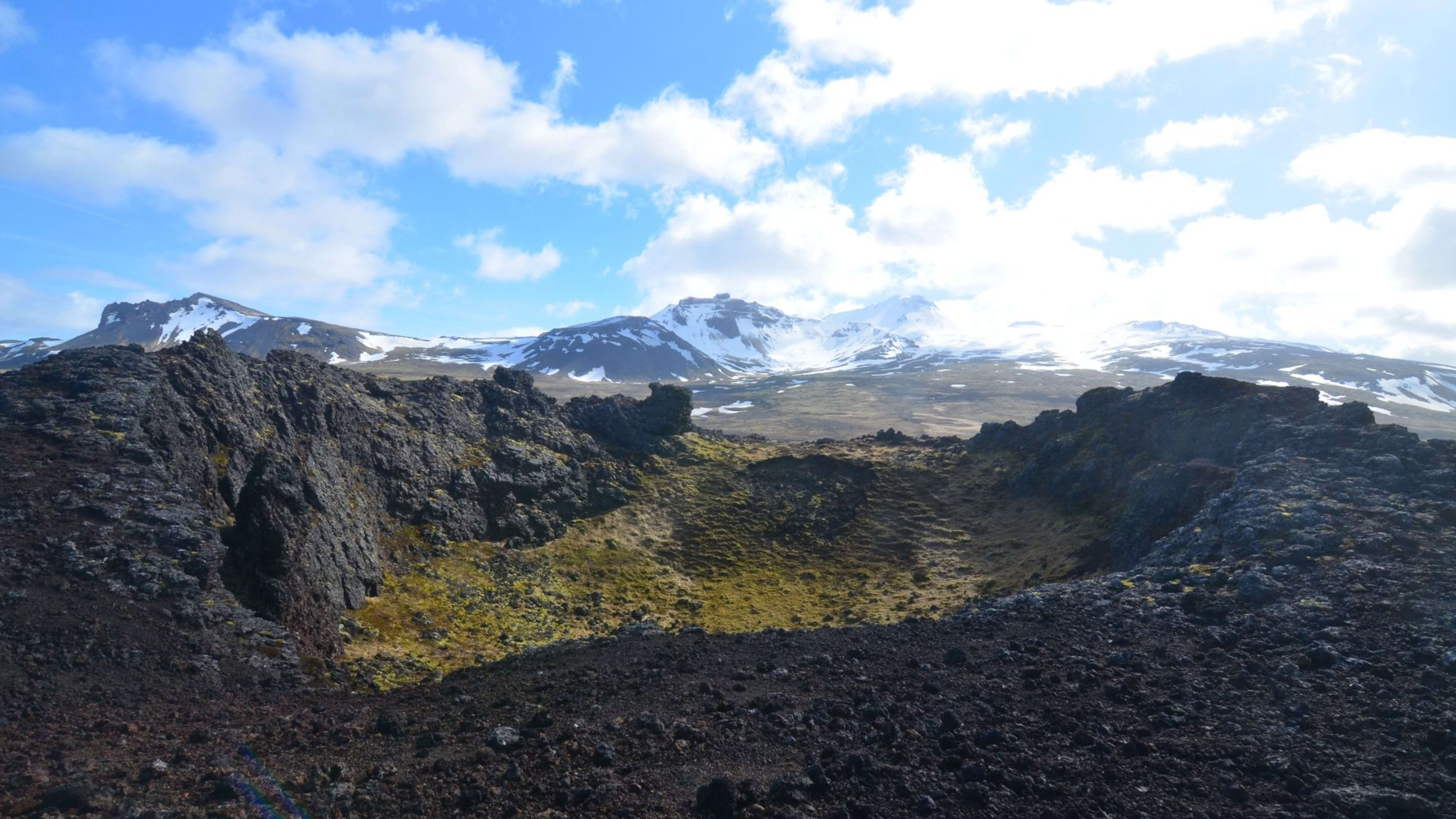
13. Mt. Brennisteinsalda (Landmannalaugar)

Distance: 6.5 km (4 mi) loop
Total ascent: 300m (1000 ft)
Many people come to the highlands for a multi-day hike, such as the Laugavegur trail, a 3–4 day walk from Landmannalaugar to Þórsmörk. You'll find many worthwhile treks that can be completed in a day.
A must-do hike is to Mt. Brennisteinsalda’s peak, one of many rhyolite mountains in the area. Nicknamed the ‘Sulphur Wave’, it’s made of a volcanic chemical that comes in many vibrant shades. To reach the highest point, you’ll pass Blahnúkúr, a blue-gray volcano.
From the top of Brennisteinsalda, you’ll have wide-open views over the Laugarhaun lava field to Landmannalaugar.
14. Laugavegur Trail (Landmannalaugar to Þórsmörk)
Distance: 55 km (34 mi) one way over 3 to 4 days Total ascent: Approximately 1,700m (5,580 ft)
The Laugavegur Trail is Iceland's most celebrated multi-day hike, running from Landmannalaugar in the highlands south to the sheltered valley of Þórsmörk. The route passes through some of the most varied terrain in the country: the coloured rhyolite mountains around the start, the black obsidian sands of Hrafntinnusker, the glacial river crossings and green slopes around Emstrur, and the birch forests of Þórsmörk at the end.
The trail is split into four stages, with overnight stops at mountain huts at Hrafntinnusker, Álftavatn, and Emstrur. Hut bunks and camping spaces must be booked well in advance, particularly for July and August departures. The season runs from late June to early September, when the F-roads to Landmannalaugar are open and the huts are staffed.
Many hikers extend the route by continuing over the Fimmvörðuháls pass to Skógar, adding roughly 25 km and one more day. Previous experience on multi-day hikes is useful but not essential if you prepare well. River crossings are part of several stages and require care, particularly early in the season when meltwater is high.
- Hike the Laugavegur Trail with Iceland Tours on a guided hiking tour.
Westfjords
The least inhabited area of Iceland, the Westfjords, is a region carved by fjords and the North Atlantic Ocean. When you’re there, look out for Arctic foxes, the famous – and elusive – natives of the region.
15. Valagil (Northern Westfjords)
Distance: 4 km (2 mi) there and back
Elevation gain: 71m (233 ft)
Valagil is a steep and dramatic ravine where you’ll discover a series of stunning waterfalls. You’ll find it at the southern end of Álftafjörður, close to the village Súðavík.
Start the walk from the parking lot on route 61. From here, you can already see one of the waterfalls in the distance. But the view gets even better as you gently climb the dirt path.
It’s an easy walk that takes you through the wild scenery of the Westfjords. Return the same way you came once you’ve snapped some photos of the ravine.
North Iceland
With its Arctic coast and lunar-like landscapes, North Iceland is a diverse area full of surprises. Take one of these hikes to explore its incredible scenery on foot. They’re all accessible from the region’s unofficial capital, Akureyri.
- Related: All about the scenic Arctic Coast Way route.
- Discover the north's remote beauty on a North Iceland & Akureyri tour.
16. Hljóðaklettar (Jökulsárgljúfur)

Distance: 3 km (2 mi) loop
Elevation gain: 55m (190 ft)
Imagine caves with bristling rocky shapes in an infinite variety of patterns. That’s what you’ll find at Hljóðaklettar, which loosely translates as ‘echo rocks’.
Hljóðaklettar is formed of basalt columns, but not like the regular stacks you’ll see at Svartifoss. Instead, these are a seemingly random mix of caves formed by volcanoes and eroded by the Jökulsá river nearby. Listen out for the eerie echoes of the river, which gives these rocks their name.
A choice of hikes can take you to these curious caves. The most direct takes about 30 minutes, but you can extend it to form a loop of about 2 hours.
17. Hverfjall (Mývatn)

Distance: 4 km (2 mi) loop or 9 km (6 mi) with extension to Dimmuborgir
Elevation gain: 118m (390 ft)
Hverfjall is one of the largest explosion craters in the world. It’s a huge area of dust and rock in a stunning symmetrical circle, formed by a volcanic eruption thousands of years ago.
The trek to Hverfjall is one of the top easy hikes North Iceland has to offer. Follow the path from the eastern shore of Lake Mývatn and climb the sandy crater to look towards the fjords of the north coast.
You can loop the entire crater or venture down into the black desert inside. On your way back, you can extend the walk by visiting Dimmuborgir, an area of unusual rock formations.
18. Súlur (Akureyri)
Distance: 12 km (7.5 mi) there and back
Elevation gain: 869m (2850 ft)
Súlur is the mountain that looms above the city of Akureyri. It’s a great achievement if you make it to the top, with panoramic views over Eyjafjörður, one of the longest fjords in Iceland.
Lace-up your boots in the large parking lot and head towards the summit. You’ll begin walking on grass, which can get muddy after rain, before it slowly becomes more rocky. It’s a steep climb, but in summer, when conditions are good, it’s reasonably straightforward.
That said, you’ll find very different conditions in winter. As the top can get very snowy, you’ll need to be prepared with winter climbing equipment, including crampons and an ice pick.
- Related: Best towns & cities in Iceland to visit.
East Iceland
East Iceland is home to giant glaciers, epic waterfalls, and the stunning Eastfjords region. There are many good routes in this vast area, but here are 2 top options.
- Visit the Eastfjords on a Ring Road tour.
19. Stuðlagil (between Mývatn and Egilsstaðir)
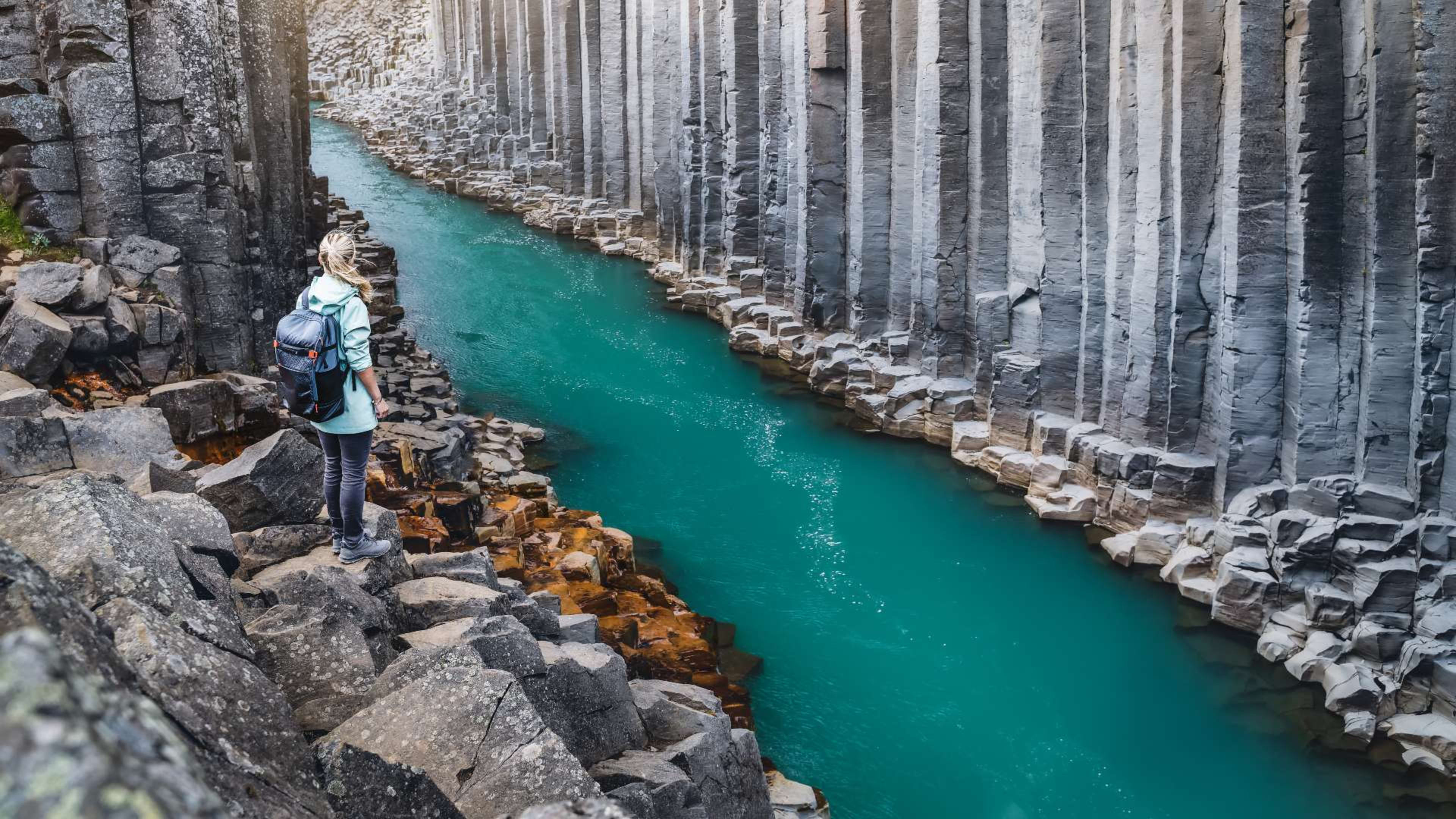
Distance: 5.3 km (3.3 mi) there and back
Elevation gain: 107m (350 ft)
Stuðlagil is a canyon surrounded by enormous cliffs made of basalt columns. As you walk between these architectural forms, walking between these basalt columns gives a strong sense of the scale of the formations.
It’s an exceptionally beautiful place, but you’ll be surprised to hear it was rarely visited until 2009 when the Kárahnjúkar Hydropower Plant was opened. The plant dammed the river and reduced its flow, meaning the canyon could be seen in all its glory.
You’ll witness the cliffs’ fascinating shapes towering over the glacial river’s blue waters below. It’s a stunning walk to the viewpoint, even though the path can get a bit muddy after it rains.
20. Fardagafoss (Egilsstaðir)
Distance: 2.6 km (1.6 mi) there and back
Elevation gain: 155m (508 ft)
The town of Egilsstaðir is an important hub for travelers in East Iceland. And thanks to its location on the banks of the Lagarfljót river, it’s a strategic base if you’re looking to hike in the region.
One scenic walk is to Fardagafoss, a striking waterfall just outside of town. From the trailhead on the road towards Seyðisfjörður, you can reach Fardagafoss in about 30 minutes. Walk up the canyon and you’ll pass another waterfall, Gufufoss, the largest in the area.
Once you reach Fardagafoss, you can walk behind the flowing stream of water. From there you can walk behind the waterfall.
3 things to remember when hiking in Iceland
With its many national parks and nature reserves, Iceland is the perfect destination for hikers.
That said, wherever you go hiking, it’s important to bear some things in mind.
1. Check the forecast before you go
The weather in Iceland can change very fast. One minute, you can be in sunshine, and the next, you’ll be surrounded by snow.
Checking the forecast is a must before you start your hike. But keep an eye on conditions throughout your journey. If you think the weather is getting worse, it’s safer to turn back, especially if you’re climbing hills.
In the colder months, you’ll often find snow on the tops of hills.
2. Pack the right kit and clothes
Another thing to consider when you’re hiking in Iceland is what you pack.
This will depend partly on the weather. If you’re visiting Iceland in fall, you’ll probably want to pack some warm layers and a waterproof jacket. In summer, if the forecast is good, you may not need it (although it’s smart to take one just in case).
In any season, sturdy shoes are a must. Paths can be slippery, muddy, and uneven, and proper shoes will help to prevent you from tripping or slipping.
- Get more handy tips and advice in this Iceland packing list.
3. Be mindful of your impact

Iceland is a beautiful place, and we should all look for ways to reduce our impact when we visit.
When hiking, we all have a role to play in preserving the landscape. You can stick to marked paths and take your litter home with you, for example. Try not to remove anything from the area, such as stones, sand, or plant material.
As the saying goes, take only photographs and leave only footprints.
Hike in the Land of Fire and Ice with Iceland Tours
Most of the hikes in this guide are accessible on a self-drive itinerary without needing specialist equipment or a guide. For the more remote routes in the Westfjords and Highlands, check conditions in advance on road.is and the Icelandic Met Office weather forecast at vedur.is. Browse Iceland adventure tours to find a self-drive, guided group, or multi-day package that covers the regions you want to explore.
Booking is easy. All you need to secure your trip is pay a 5% deposit today.
FAQs about day hiking in Iceland
Iceland's hiking trails are accessible to most fitness levels, but the conditions and preparation required vary by season and location. Here are answers to the most common questions.
Most of the popular day hikes in Iceland are well-marked and do not require a guide. Trails at Skaftafell, Reykjadalur, Hverfjall, and Mount Esja are all manageable independently with appropriate footwear and weather awareness. For more remote areas like the Westfjords or Highlands, checking trail conditions in advance is important, and hiring a guide is worth considering outside of peak season.
Waterproof and windproof outer layers are essential regardless of season. Sturdy, waterproof hiking boots with ankle support are strongly recommended as trails can be muddy, uneven, and wet. Thermal base layers are useful from September through May. Even in summer, temperatures can drop quickly at elevation, so carrying an extra layer is advisable.
June through August offers the most accessible conditions, with long daylight hours and generally passable trails. Some higher routes, including Súlur above Akureyri and Brennisteinsalda in Landmannalaugar, require caution in winter due to snow and ice. The Fagradalsfjall volcano routes on the Reykjanes peninsula are accessible year-round but should be checked before visiting.
Most hiking trails in Iceland are free to access. Skaftafell and other areas within Vatnajökull National Park charge a parking fee but no trail entry fee. The Reykjadalur valley near Hveragerði is also free. Some of the more developed areas have paid car parks at the trailhead.
The Icelandic Met Office at vedur.is publishes weather forecasts by region and is the standard reference for hikers. Road and trail closures are listed at road.is. For highland and Westfjords routes, it is worth checking the Safetravel Iceland website at safetravel.is, which also has a registration system for solo hikers.