The Five Cairns Pass
Fimmvörðuháls, meaning "five cairns pass" in Icelandic, occupies the mountain pass between two of Iceland's most famous glaciers, Eyjafjallajökull to the west and Mýrdalsjökull to the east. This dramatic highland area connects the coastal village of Skógar with the remote valley of Þórsmörk via one of Iceland's most spectacular and challenging hiking trails. The pass reaches elevations around 1,100 meters above sea level, placing hikers in an exposed alpine environment where weather can change with dramatic speed.
The name references five ancient stone cairns that once marked the route across the pass, guiding travelers through this treacherous landscape before modern trail markers existed. These cairns served as lifesaving navigation aids when fog or snow obscured visibility, helping shepherds, traders, and travelers find their way between the coastal lowlands and the highland interior. Today, the trail is well-marked with posts and stakes, though the challenging terrain and unpredictable weather still demand respect and preparation from hikers.
Birth of New Craters in 2010
Fimmvörðuháls gained worldwide attention in March 2010 when it became the site of the first phase of the Eyjafjallajökull eruption sequence. On March 20, at approximately 23:00, a 500-meter-long fissure opened on the northern part of the pass, beginning what Icelanders affectionately call "the tourist eruption." Lava fountains shot hundreds of meters into the air, creating a spectacular display that drew thousands of visitors who could safely observe the eruption from nearby vantage points.
Just over a week later, the eruption intensified, and two new craters began forming near Þórsmörk. These craters were officially named Magni and Móði on June 15, 2010, after the sons of Thor in Norse mythology. The names, meaning "brave" and "strong," perfectly suit their location near the Valley of Thor and their dramatic formation during one of Iceland's most watched volcanic events. The eruption streamed lava downhill, creating the new Goðahraun lava field, whose name means "lava field of the gods."
The lava from these craters still emanates heat years after the eruption. Snow cannot settle on the rocks around the crater rims, and on cold days they often appear to be steaming. Visitors placing their hands on the volcanic stone can feel warmth even in cool weather, a tangible connection to the intense heat that created these features. The craters represent some of the youngest volcanic formations in Iceland, offering hikers a rare opportunity to witness geological features still actively cooling.
A Trail of Waterfalls
The Fimmvörðuháls Trail stretches approximately 22 to 25 kilometers from Skógar to Þórsmörk, requiring hikers to ascend about 1,000 meters over challenging terrain. The journey typically takes 10 to 14 hours for fit hikers completing it in a single day, though many choose to split the trek over two days, staying overnight in one of the mountain huts along the route.
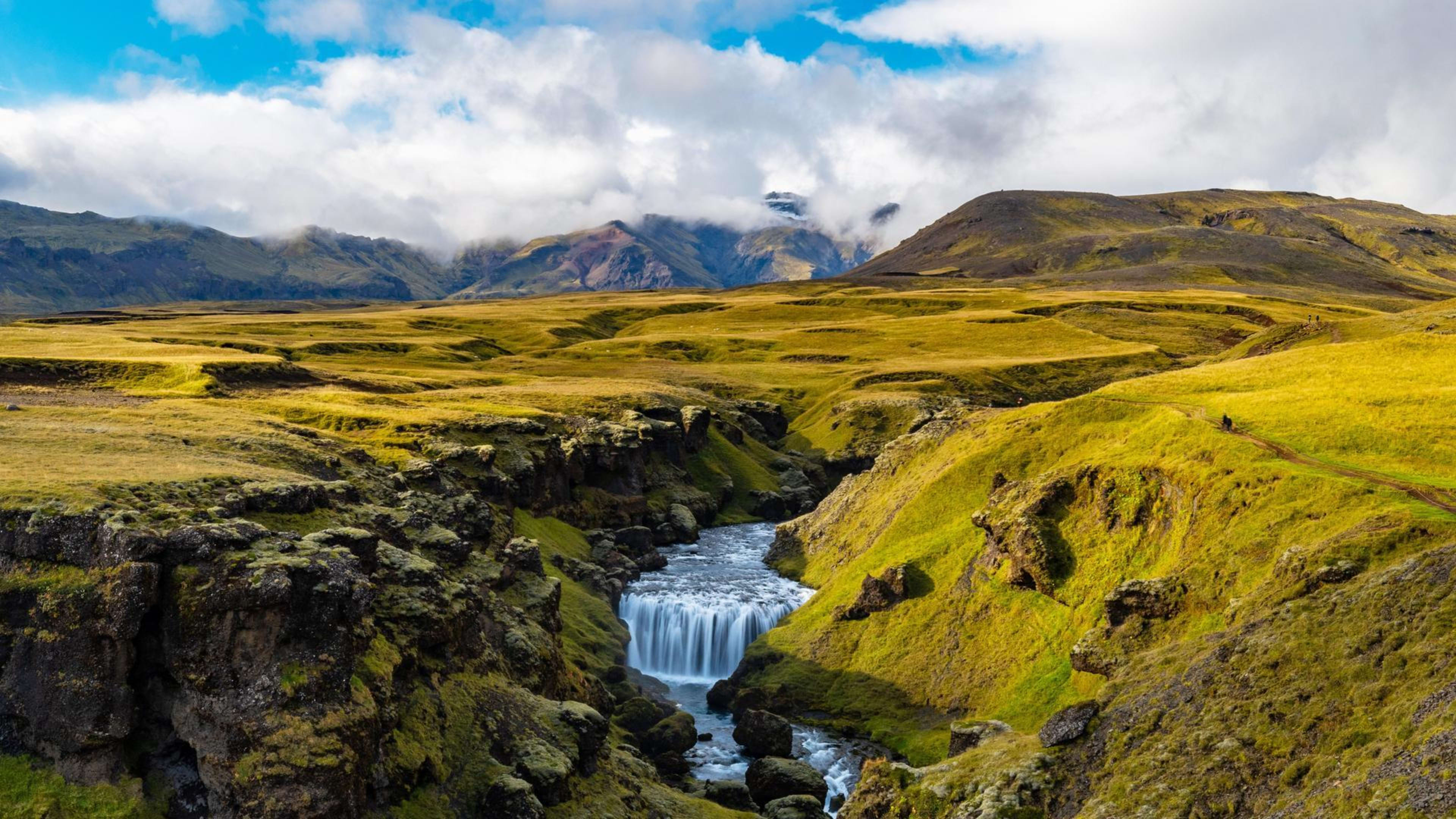
The trail begins at Skógafoss, one of Iceland's largest and most famous waterfalls, where hikers must climb a staircase beside the powerful cascade. From there, the route follows the Skógá river upstream, revealing an incredible sequence of waterfalls. Over 26 named waterfalls line this section, creating what hikers call "Waterfall Way," each cascade unique in character and beauty. The constant sound of rushing water and the spray from multiple falls create an immersive experience unlike anywhere else in Iceland.
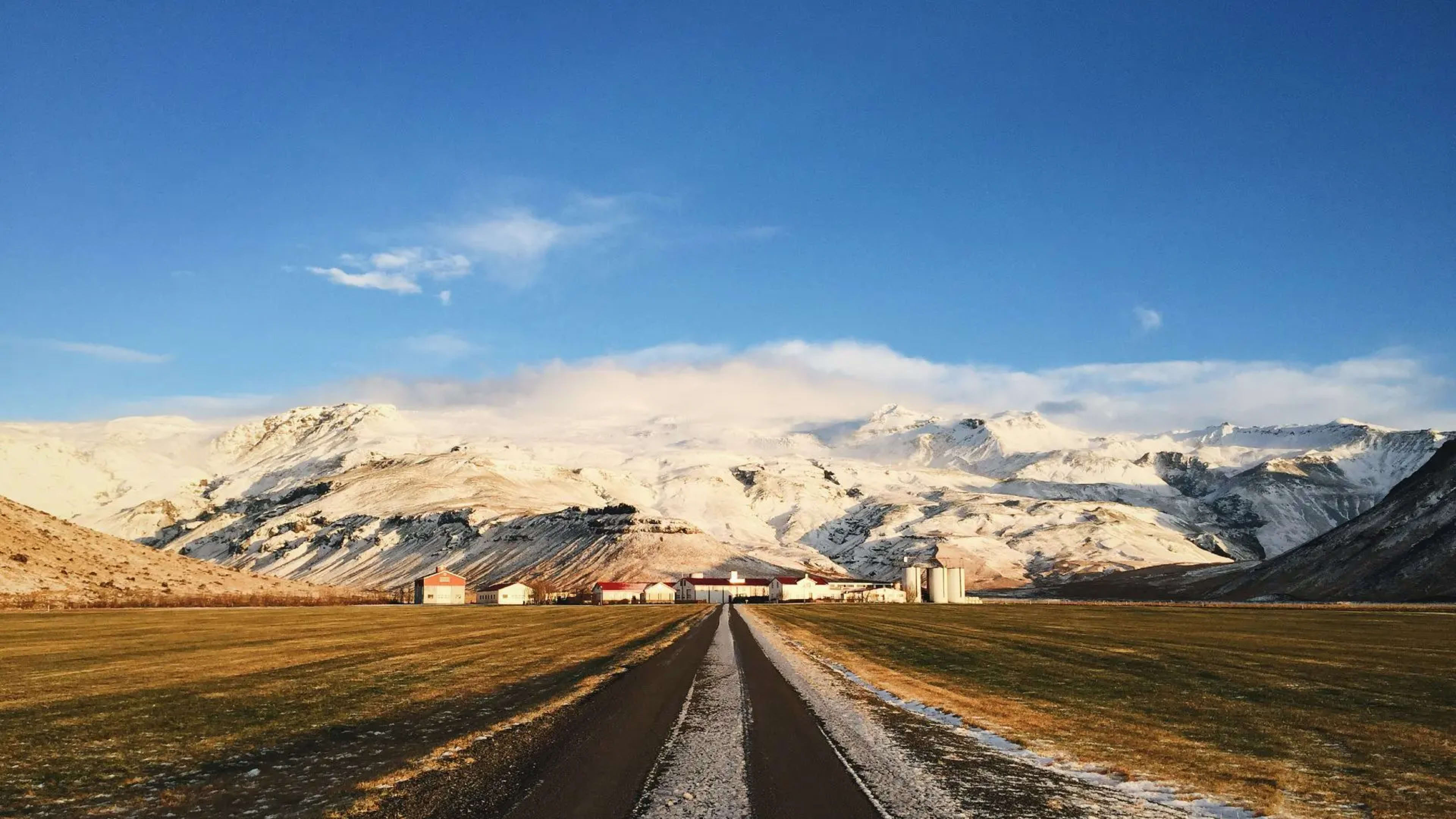
After approximately 8 kilometers of waterfalls, hikers cross a bridge over the Skógá river and the landscape begins to change. The trail either follows a gravel road or takes a marked path leading to Baldvinsskáli hut, a basic shelter operated by Útivist that accommodates 16 people. This hut provides a crucial rest stop roughly halfway through the trek, offering shelter from the increasingly harsh conditions found at higher elevations.
Crossing the Highland Pass
Beyond Baldvinsskáli, the trail climbs to the actual Fimmvörðuháls pass, crossing terrain that can be covered in snow well into summer. The route is marked with stakes, but fog, strong winds, and sudden storms can make navigation challenging. About 3 kilometers past the hut, hikers reach the Goðahraun lava field, its black volcanic rock still fresh and jagged from the 2010 eruption.
The Magni and Móði craters sit near the high point of the trail, their jagged rims and small lava flows providing dramatic evidence of the forces that shaped this landscape. A short detour to climb these craters rewards hikers with sweeping views across the volcanic terrain, with glaciers visible in multiple directions. The contrast between the fresh black lava and the ancient white ice creates one of Iceland's most striking visual spectacles.
Beyond the craters, hikers encounter several challenging sections. Brattafönn, a steep slope, can remain icy even in summer and requires careful footing. Heljarkambur, a narrow ridge, features a support chain on its most exposed section, providing reassurance for those uncomfortable with heights. The views from this ridge are extraordinary but demand focus and sure footing.
Morinsheiði heath follows, offering panoramic views of Mýrdalsjökull and the hidden Katla volcano beneath its ice. The landscape here feels vast and exposed, with the trail crossing a flat highland plateau before reaching Kattarhryggir, "the Cat's Spine." This stunning mountain ridge features a narrow path with steep drops on both sides, creating an exhilarating finish to the highland section. Many hikers compare the dramatic scenery to scenes from fantasy films, with the combination of glaciers, volcanic landscapes, and vertiginous ridges creating an almost mythical atmosphere.
Descent into Þórsmörk
After crossing Kattarhryggir, the trail descends steeply into Þórsmörk valley. This descent provides stunning views back toward the glaciers and lava fields, allowing hikers to appreciate the full sweep of terrain they have crossed. The landscape transforms dramatically as elevation drops, with the barren volcanic highlands giving way to the lush green valleys of Þórsmörk.
The contrast could not be more striking. From the exposed, wind-swept pass with its fresh lava and ancient glaciers, hikers descend into a verdant world of birch forests, moss-covered rocks, and flowing streams. The air grows warmer and more humid, the wind drops away, and the sound of birdsong replaces the howl of highland gusts. This transformation creates one of the most memorable moments of the entire trek, with many hikers feeling as though they have passed between two different worlds.
A Memorial to Respect Nature
A memorial cairn along the trail commemorates hikers who died in the pass during a severe snowstorm on the night of May 16, 1970. This sobering reminder underscores the serious nature of hiking in Iceland's highlands and the importance of proper preparation, appropriate gear, and respect for rapidly changing weather conditions. The tragedy occurred despite the trail's popularity, demonstrating that even well-traveled routes can become deadly when conditions deteriorate.
The memorial serves as a call for caution to all who hike Fimmvörðuháls. Weather in the pass can shift from clear and calm to whiteout conditions within minutes. Summer snow, freezing rain, and winds strong enough to knock hikers off their feet are all possible even in July and August. Hikers must check weather forecasts, carry proper clothing and emergency supplies, and be prepared to turn back if conditions worsen.
Combining Iceland's Greatest Trails
Many hikers add Fimmvörðuháls to the Laugavegur Trail, creating a comprehensive 6-day trek covering approximately 80 kilometers through Iceland's most spectacular landscapes. This combination allows hikers to experience the full range of Iceland's highland environments, from the colorful rhyolite mountains and geothermal features of Landmannalaugar, through the volcanic deserts and high plateaus of the Laugavegur route, over the dramatic pass of Fimmvörðuháls with its fresh craters, and down through countless waterfalls to the coast at Skógar.
The trail is accessible only during summer, typically from mid-June through late August when snow has cleared from the pass and the mountain huts are staffed. Even during this window, conditions can be challenging, and hikers should be physically fit with good hiking experience. The 1,000-meter elevation gain, combined with potentially difficult weather and the technical sections like Kattarhryggir, make this a serious undertaking requiring proper preparation.