A Desert Oasis in the Highlands
Emstrur sits at 465 meters (1,525 feet) elevation in Iceland's southern highlands, representing a transition zone between the exposed volcanic deserts to the north and the increasingly verdant terrain leading south toward Þórsmörk. The region takes its name from its historical use as summer grazing lands, where farmers brought their sheep to feed on the highland vegetation during the warmer months. This pastoral tradition connected lowland farms with the remote interior, utilizing resources in areas otherwise too harsh for permanent settlement.
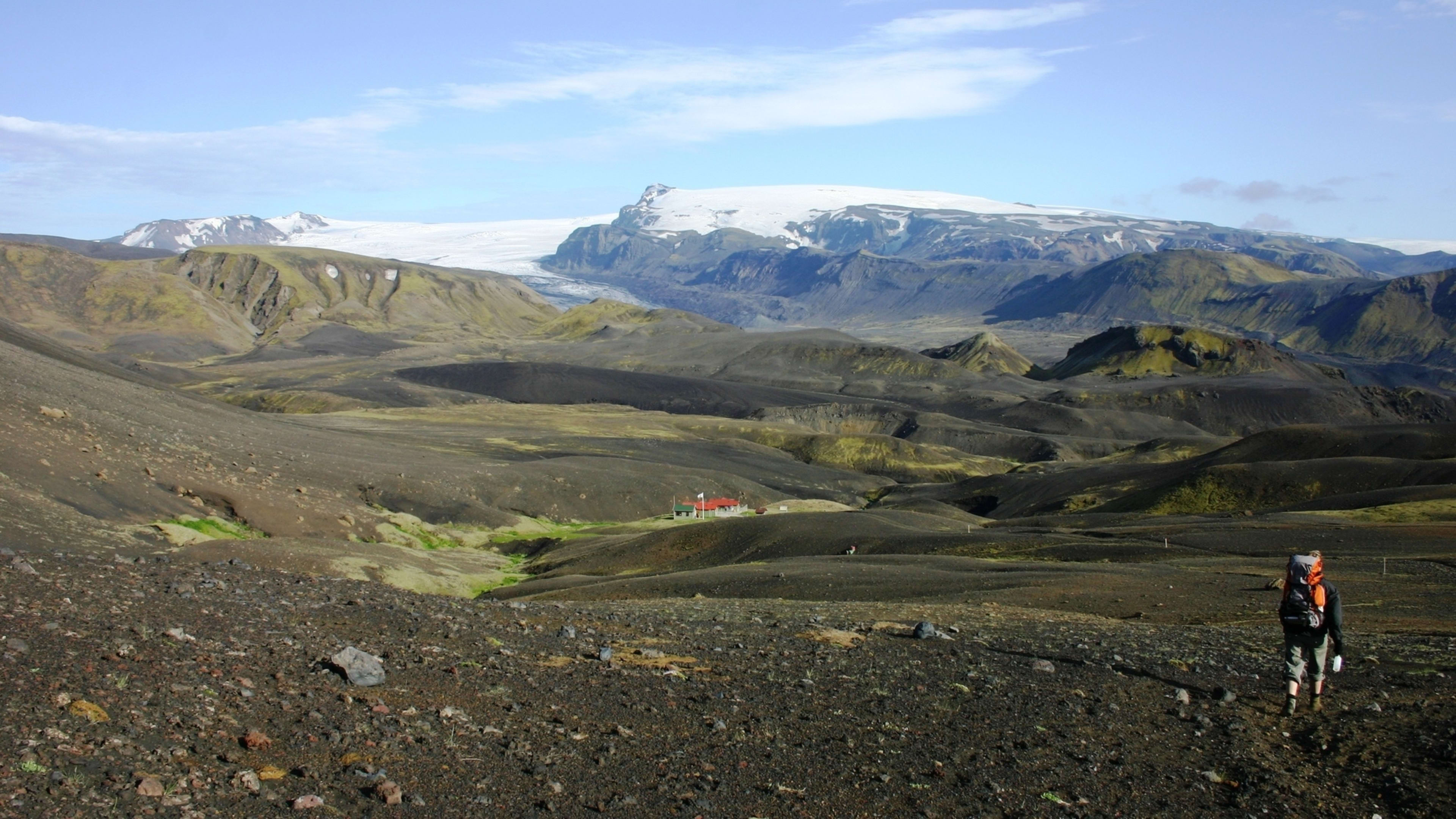
The landscape around Emstrur presents a study in contrasts. Black sand plains and steep ravines dominate the immediate surroundings, yet the area where the Botnar huts sit forms a surprisingly green oasis nestled in a small valley. This sheltered location provides protection from the relentless winds that sweep across the open desert, allowing vegetation to establish itself and creating a welcoming refuge for tired hikers completing one of the longer sections of the Laugavegur Trail.
The Botnar Mountain Huts
The Botnar huts in Emstrur consist of three identical small buildings that together accommodate 60 people, making this one of the more intimate stops along the Laugavegur Trail. Built and operated by the Icelandic Touring Association, each hut houses 20 hikers in 10 double bunk beds, with all facilities compressed into a single open-plan room. The sleeping area shares space with a small kitchen and dining area, creating close quarters that foster a communal atmosphere among hikers.
All three huts connect via boardwalks to a separate toilet and shower building, which also features sinks for washing up. These covered walkways provide sheltered access even when weather turns harsh, a thoughtful design feature for this exposed location. A small additional hut houses the wardens who manage the facility and provide guidance to hikers about weather conditions and trail status.
The huts are equipped with gas stoves, cooking utensils, and cold running water, allowing hikers to prepare their own meals in the communal kitchen. Like other facilities along the Laugavegur Trail, there is no electricity, so hikers must bring power banks if they need to charge electronic devices. The lack of modern conveniences encourages social interaction and helps maintain the wilderness character of the trail experience.
Outside the huts, a large terrace connects the buildings and provides an excellent outdoor sitting area. On calm evenings, this becomes a gathering place where hikers share stories, watch the sunset illuminate the surrounding peaks, and enjoy the remarkable sense of solitude that comes from being deep in Iceland's uninhabited interior. The views from the terrace can be spectacular on clear days, with distant glaciers dominating the skyline.
Camping in the Highlands
The campsite at Emstrur offers several options for pitching tents. A large open area sits just above the main hut buildings, providing easy access to facilities but with significant exposure to wind. Several more secluded pitches can be found just below the huts, tucked into the landscape's folds where they gain some protection from prevailing winds. Campers have access to the toilet and shower facilities, making the camping experience more comfortable while maintaining the sense of sleeping in Iceland's wilderness.
The small valley containing the huts and campsite creates a surprisingly lush environment compared to the surrounding black deserts. The fold in the terrain traps moisture and provides shelter from wind, allowing grasses and other vegetation to grow. This greenery provides visual relief after crossing the stark volcanic landscapes of Mælifellssandur and creates a more pleasant environment for an overnight stay.
Rolling Valleys and Deep Canyons
The Emstrur region extends beyond the immediate hut area, encompassing a landscape of small valleys and gullies that roll across the highland terrain. The great Mýrdalsjökull glacier rises only a few kilometers to the south, its massive ice cap visible on clear days and serving as a constant reminder of the powerful geological forces at work in this region. Meltwater from the glacier feeds the rivers that carve through Emstrur, creating the deep canyons that characterize the area.
The Syðri-Emstruá river flows through one such canyon, crossed via a footbridge that provides one of the trail's most dramatic moments. The narrow gorge drops away steeply on both sides of the bridge, with the river roaring far below. After crossing, hikers climb to a higher plateau that offers breathtaking views of where the Syðri-Emstruá and Markarfljót rivers converge in deep canyons carved into the volcanic rock.
These canyons demonstrate the erosive power of glacial meltwater. The rivers, fed by Iceland's massive ice caps, carry enormous volumes of water along with sediment and volcanic debris. Over time, this constant flow has cut deep channels through solid rock, creating gorges that rival any in Iceland for depth and drama. The thundering sound of water rushing through narrow passages adds an auditory dimension to the visual spectacle.
Historic Grazing Lands
For centuries before the Laugavegur Trail became a popular hiking route, Emstrur served as summer pasture for sheep from farms in the lowlands. The practice of bringing livestock to highland grazing areas, known as afrétt, allowed farmers to make use of vegetation that grew during the brief summer season while preserving meadows closer to their farms for winter hay.
Shepherds would spend weeks in the highlands tending their flocks, building temporary shelters and stone enclosures to protect sheep from the elements and keep them gathered. The remains of these structures can still be found throughout the Emstrur region, silent testimony to the hardy people who made their living in this challenging environment. The construction of proper mountain huts in the late 20th century transformed Emstrur from a working landscape into a recreational one, though the connection to Iceland's pastoral past remains evident.
The name Emstrur itself reflects this agricultural heritage, referring to the practice of keeping ewes in the highlands. This linguistic connection ensures that modern hikers walking through the region remain aware of its history, even as they experience it primarily as wilderness rather than working land.
The Final Highland Night
For most hikers on the Laugavegur Trail, Emstrur represents their final night in the true highlands before descending into Þórsmörk. After three days of exposed ridges, geothermal valleys, and volcanic deserts, the small green oasis at Botnar provides a fitting place to reflect on the journey so far and prepare for the final day's trek.
The location allows hikers to appreciate how far they have come, both literally and in terms of landscape traversed. Looking north, they can trace their route back across Mælifellssandur toward the green cone of Hattfell and beyond to Álftavatn and the high plateau of Hrafntinnusker. Looking south, they can see the terrain beginning its descent toward the coast, with vegetation becoming more abundant and the massive glaciers drawing closer.
Evening light at Emstrur can be particularly beautiful, illuminating the hills around the huts and casting the distant glaciers in golden hues. Many hikers report that watching sunset from the terrace at Botnar, knowing they have successfully navigated the most challenging sections of the trail, ranks among their most memorable moments on the trek.
Approaching Þórsmörk
From Emstrur, the trail continues south through the rolling valleys and gullies that characterize the region. The route becomes progressively more vegetated as hikers descend, with the stark volcanic terrain gradually giving way to moss-covered hills and increasing patches of hardy plants. The massive Mýrdalsjökull glacier looms ever larger to the east, its presence dominating the landscape and reminding hikers of the ice that shapes this region.
The 15-kilometer trek from Emstrur to Þórsmörk marks the final major section of the Laugavegur Trail. This stage involves crossing the Syðri-Emstruá canyon, traversing the Almenningar area with its small ravines, and eventually descending into the lush birch forests that mark the beginning of Þórsmörk. The transformation from highland desert to forested valley represents the trail's final dramatic landscape shift, providing a fitting conclusion to the multi-day journey.


