A Hidden Gorge in the Highlands
Markarfljótsgljúfur, the canyon of the Markarfljót river, plunges 200 meters (656 feet) into the volcanic bedrock of Iceland's southern highlands, creating one of the country's most impressive yet least visited natural gorges. This dramatic canyon cuts through the landscape near the Emstrur region along the famous Laugavegur Trail, offering hikers willing to take a short detour one of the trail's most spectacular geological sights.
The canyon stretches for approximately 4 kilometers through the highland terrain, with the Markarfljót river roaring through its depths like a jet engine. Despite its captivating beauty and impressive scale, Markarfljótsgljúfur remains relatively unknown compared to Iceland's more accessible canyons, enhancing its pristine quality and sense of remote wilderness. The challenging journey required to reach it, deep within the uninhabited highlands, ensures that visitor numbers remain low.
Carved by Catastrophic Floods
The formation of Markarfljótsgljúfur tells a dramatic story of volcanic power and glacial flooding. Geologists believe the canyon was created approximately 2,000 years ago during a catastrophic jökulhlaup, or glacial outburst flood, triggered by an eruption of Katla volcano beneath the Mýrdalsjökull glacier. While most floods from Katla eruptions flow eastward, this particular event found its way west, carving a massive gorge through the volcanic rock with devastating force.
The Markarfljót river itself stretches 100 kilometers from its source near Hrafntinnusker to the sea in the Landeyjar islands. The main source lies in the northern part of Mýrdalsjökull glacier, with meltwater from both Mýrdalsjökull and Eyjafjallajökull feeding the river as it flows toward the coast. This massive watercourse has carried millions of tons of sand and sediment southward over the centuries, creating the Markarfljótsaurar outwash plain visible near the coast.
The canyon's walls reveal layers of volcanic rock accumulated over thousands of years, each stratum telling part of Iceland's geological story. The sheer power required to carve such a deep gorge in solid volcanic rock demonstrates the incredible force of the floods that swept through during the volcanic event. Standing at the canyon's edge and imagining the volume of water that thundered through helps visitors comprehend the scale of Iceland's most powerful geological processes.
A Detour Worth Taking
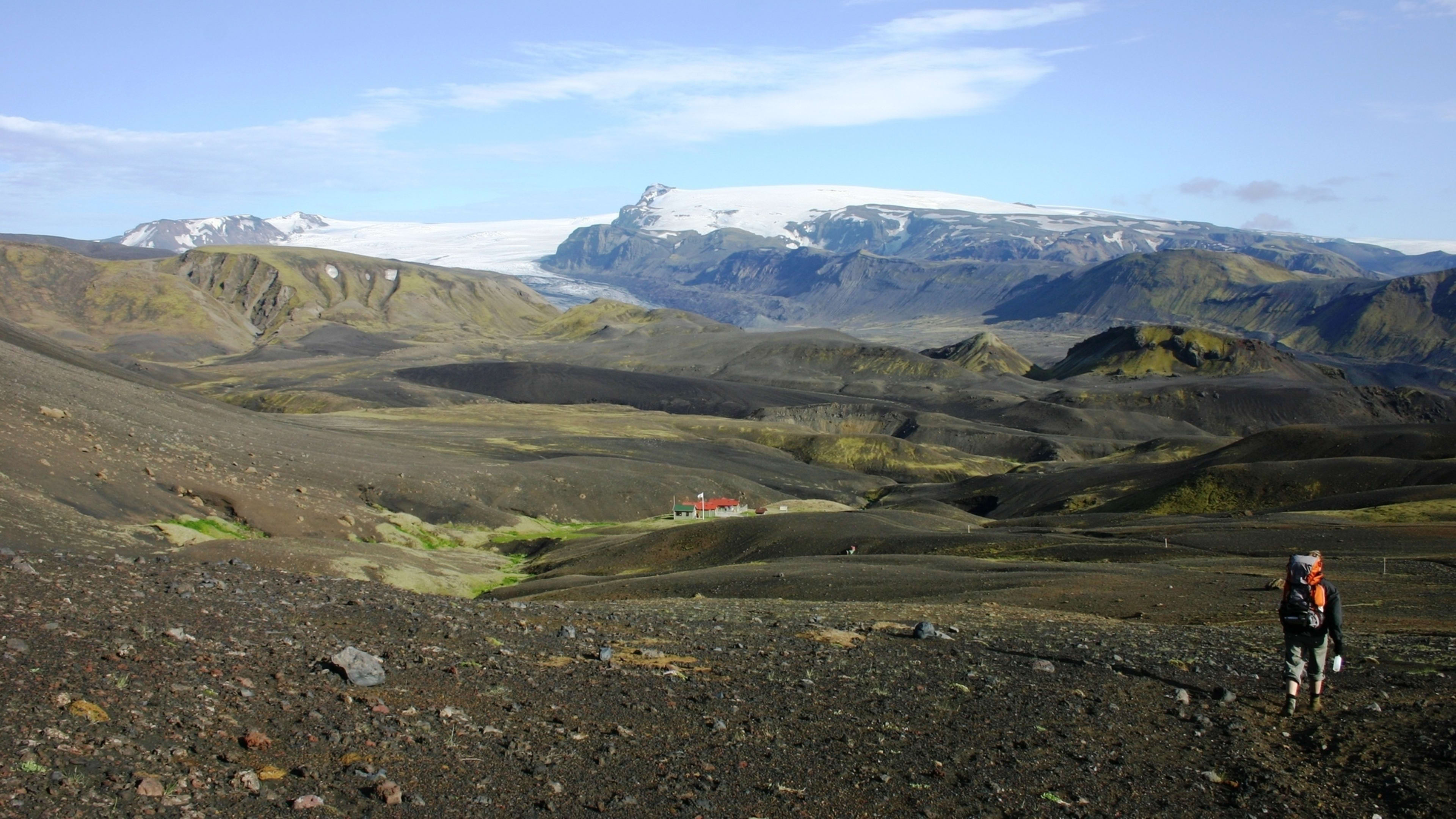
Hikers on the Laugavegur Trail can access Markarfljótsgljúfur via a short detour from the main route between Hvangil and the Botnar huts in Emstrur. The side trail requires only about 10 to 15 minutes of walking from the main path, making it an accessible addition to the day's hike. Despite the minimal extra effort required, many hikers bypass the canyon in their eagerness to reach the shelter of the huts, making those who do visit feel as though they are discovering a secret wonder.
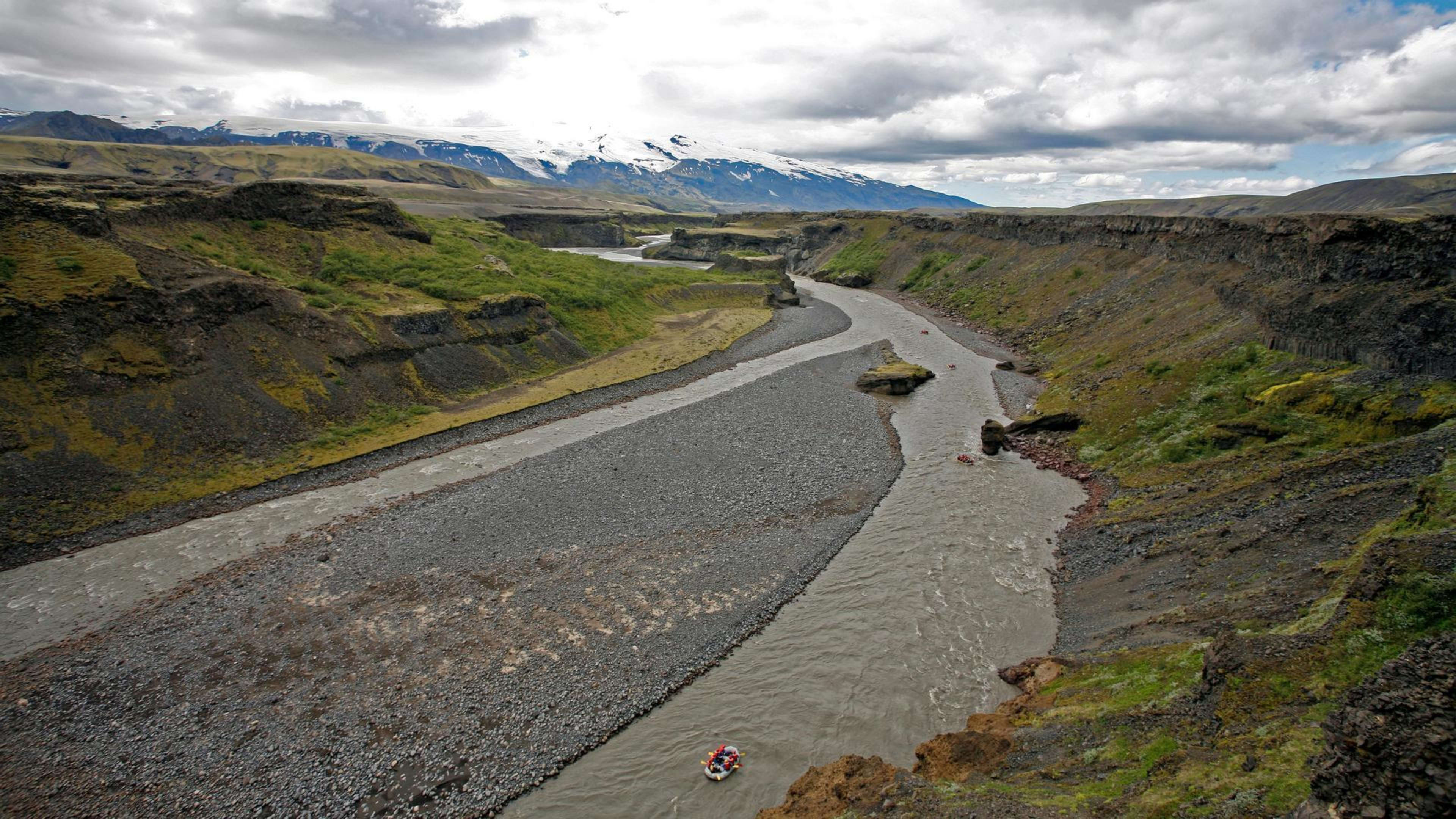
The viewpoint on the east side of the canyon, accessible from the Laugavegur Trail, provides dramatic perspectives of the gorge where the Markarfljót and Syðri-Emstruá rivers meet. The convergence of these two powerful watercourses creates a spectacular display of flowing water and churning rapids. The canyon walls drop away precipitously, revealing the depth and power of the erosion that created this feature.
From the viewing platforms, hikers can see Hattfell volcano to the north, its green moss-covered slopes providing a striking contrast to the dark volcanic rock of the canyon walls. To the south, views extend across the highlands toward the massive ice caps of Mýrdalsjökull and Eyjafjallajökull. On clear days, the perspective encompasses the full sweep of the southern highland landscape, from volcanic peaks to glaciated summits.
Eastern and Western Approaches
The canyon can be approached from both its eastern and western sides, though most Laugavegur Trail hikers only visit the east side viewpoint. The western approach requires accessing the highland road Syðri Fjallabak via Emstruleið F261, a challenging mountain road suitable only for experienced drivers in proper 4WD vehicles. This route serves as a gateway when entering the Fljótshlíð area from southern Iceland through the rugged Emstrur terrain.
Driving F261 provides access to multiple viewpoints along the canyon's western rim, offering different perspectives on the gorge and the Markarfljót river flowing through it. A waterfall along the river near one of the western trailheads provides an additional natural attraction for those exploring by vehicle. However, the rough road conditions and remote location mean that most visitors who see the canyon do so as part of their Laugavegur Trail hike rather than as a separate driving excursion.
The combination of the canyon's natural beauty and the exhilarating hiking experience creates a memorable adventure for those who venture into this less-traveled part of Iceland. The interplay of light and shadow on the canyon walls, particularly during the extended daylight hours of summer, creates constantly changing visual displays. Photographers find the canyon particularly rewarding, with opportunities to capture the scale of the gorge, the power of the river, and the surrounding volcanic landscape.
An Undervisited Wonder
Markarfljótsgljúfur's relative obscurity compared to more famous Icelandic canyons like Fjaðrárgljúfur works in its favor, preserving a sense of discovery and wilderness that has been lost at more popular sites. The canyon receives most of its visitors during the peak Laugavegur Trail hiking season between July and August, yet even then it remains quiet compared to Iceland's roadside attractions.
The serene atmosphere at the canyon allows visitors to connect deeply with the landscape. The sounds of the rushing river far below, the wind sweeping across the highland plateau, and the occasional calls of birds create an immersive natural experience. The absence of development, interpretive signs, or tourist infrastructure maintains the raw character of the site, allowing the geological features to speak for themselves.
For those hiking the Laugavegur Trail, the canyon represents one of several highlights that justify the effort required to trek through the highlands. While the colorful mountains of Landmannalaugar and the geothermal features of Jökultungur attract more attention, Markarfljótsgljúfur offers a different kind of spectacle: the raw power of water cutting through volcanic rock, creating a monument to the forces that continue to shape Iceland's landscape.