
Your Guide to Lakagígar - Iceland's Most Powerful Volcanic Scar
Lakagígar (also called the Laki craters) is one of those places that'll completely change how you think about volcanic power. This incredible 25-kilometer line of craters and volcanic fissures cuts through the Icelandic highlands like a massive scar across the landscape - and the story behind how it formed is absolutely mind-blowing.
Picture this - 135 volcanic craters stretching as far as you can see, created during one of the most devastating eruptions in recorded history. The 1783-1784 Laki eruption didn't just reshape Iceland's landscape - it literally changed the climate of the entire Northern Hemisphere and contributed to events as far away as the French Revolution.
Located in the Icelandic highlands within Vatnajökull National Park, Lakagígar sits about 50 kilometers northeast of Kirkjubæjarklaustur. Getting there is an adventure in itself, requiring proper highland vehicles and summer-only access, but trust me - seeing this volcanic wonderland up close is totally worth the effort.
The 1783 Laki Eruption - When Iceland Almost Ended the World
Here's where things get seriously dramatic. The Laki eruption began on June 8, 1783, and what followed was basically a volcanic apocalypse that lasted eight months.
The Eruption Timeline
June 8, 1783: A 25-kilometer fissure split open along Laki mountain, with lava fountains shooting hundreds of meters into the air
Summer 1783: Peak activity with massive lava flows that you can still walk on today
Winter 1783-1784: Continued eruptions with toxic gas emissions poisoning the atmosphere
February 1784: The eruption finally ended, but the damage was already done
The Staggering Scale
Get this - the Laki eruption produced more lava than any other eruption in recorded history:
- Lava volume: 14.7 cubic kilometers - enough to bury all of Manhattan under 300 meters of rock
- Gas emissions: 122 million tons of sulfur dioxide plus massive amounts of other toxic gases
- Ash cloud: Reached across Europe, North America, and even North Africa
- Duration: 8 months of continuous volcanic hell
The Móðuharðindin - Iceland's Darkest Chapter
Icelanders called the aftermath of the Laki eruption "Móðuharðindin" - the "Mist Hardships" - and it was absolutely devastating. The toxic gases and ash didn't just create pretty sunsets - they poisoned everything.
The Immediate Impact on Iceland
Livestock catastrophe: 80% of sheep, 75% of horses, and 50% of cattle died from fluorine poisoning Crop failures: Toxic ash contaminated grasslands and water sources Human toll: About 20% of Iceland's population died from famine and disease Social collapse: Traditional farming communities were completely destroyed
The toxic mist: Sulfur dioxide and other gases created this deadly haze that hung over Iceland for months. People described the air as burning their lungs and the taste of metal in their mouths.
Global Climate Chaos
But here's what's really incredible - the eruption's effects went way beyond Iceland:
European climate disruption: The summer of 1783 was one of the hottest on record, followed by one of the coldest winters Crop failures across Europe: France, England, and other countries experienced massive agricultural disasters Social unrest: Food shortages and economic chaos contributed to the conditions that sparked the French Revolution in 1789 Global temperature drop: The eruption caused global cooling that lasted for years
Exploring Lakagígar Today
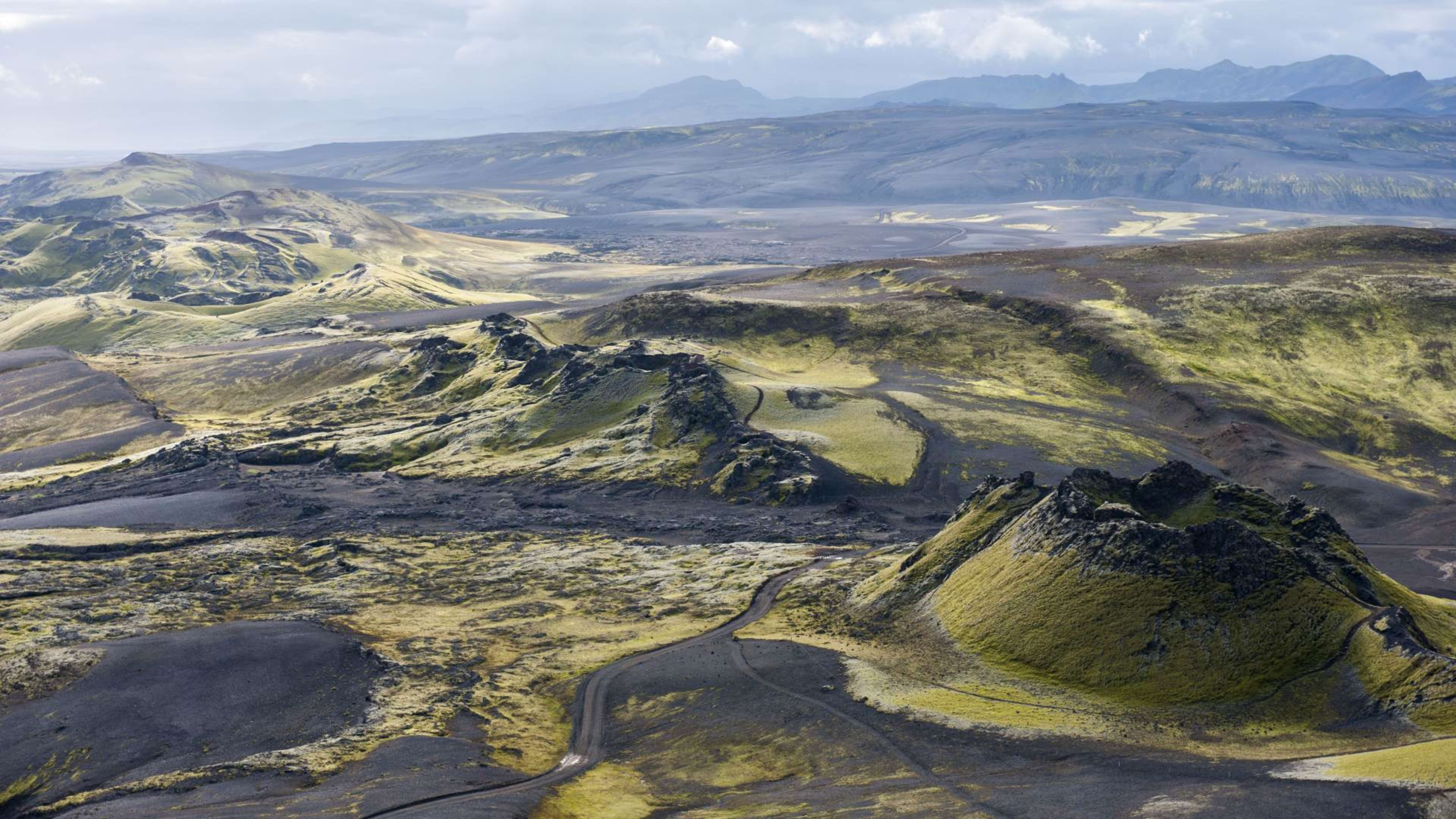
Today, Lakagígar is this incredible landscape that lets you walk through one of history's most powerful volcanic events. The craters have been mostly reclaimed by moss and vegetation, creating this surreal green carpet over the dark volcanic rock.
What You'll See
The crater row: 135 individual craters stretching 25 kilometers across the highland landscape Lava fields: Massive flows of solidified lava that look like frozen black rivers Eldgjá canyon: Part of the same volcanic system, this 40-kilometer canyon is equally dramatic Moss-covered moonscapes: The contrast between green moss and black lava is absolutely stunning
Hiking Options
Laki mountain summit: Moderate hike to the top for incredible views over the entire crater system Crater rim walks: Easy walks along the edges of individual craters Lava field exploration: Wander through the solidified lava flows (stick to marked paths to protect the moss) Photography spots: Multiple viewpoints perfect for capturing the scale of this volcanic landscape
Pro tip: The hiking here is relatively easy, but the scale is what's incredible. You can spend hours just trying to comprehend how massive this eruption really was.
Getting to Lakagígar - Highland Adventure Required
Here's where things get interesting - reaching Lakagígar requires serious preparation and the right vehicle. This is proper highland territory that's only accessible during summer months.
The Highland Route
Road F206: The main access route from the Ring Road near Kirkjubæjarklaustur Distance: About 50 kilometers of rough highland road Vehicle requirements: 4WD absolutely essential - no exceptions Season: Typically late June through early September only Conditions: River crossings, rough gravel, and potential for rapid weather changes
Driving Essentials
Proper 4WD vehicle: Highland-rated rental with good clearance Emergency supplies: Extra food, water, warm clothes, and communication device Route planning: Download offline maps and check road conditions at road.is Fuel: Fill up before heading into the highlands - no services available
Good to know: The drive itself is part of the adventure, with incredible highland scenery and a real sense of wilderness exploration.
Tour Options
If highland driving sounds too intense, joining a super jeep tour is a smart move. These specialized tours use vehicles designed for highland conditions and include expert guides.
Tour advantages:
- Professional drivers who know the terrain
- Vehicles equipped for challenging conditions
- Expert geological and historical commentary
- No stress about navigation or vehicle requirements
Tour types:
- Day trips from Reykjavík or the south coast
- Combination tours including other highland attractions
- Photography-focused tours for the best shots
- Multi-day highland adventures
The Science Behind the Devastation
Understanding why the Laki eruption was so devastating helps you appreciate what you're seeing when you visit.
Why Laki Was Different
Fissure eruption: Instead of one central volcano, the eruption happened along a 25-kilometer crack in the earth Gas composition: Massive sulfur dioxide emissions created acid rain and toxic atmospheric conditions Duration: Eight months of continuous activity meant sustained environmental damage Volume: The sheer amount of lava and gas was unprecedented in recorded history
Modern Volcanic Monitoring
Current activity: The Laki system is closely monitored by Icelandic scientists Early warning systems: Modern technology can detect volcanic unrest months or years in advance Preparedness: Iceland now has comprehensive plans for dealing with major eruptions
Fun fact: Scientists study Lakagígar to understand how massive volcanic eruptions might affect our modern world - the lessons learned here help prepare for future events.
Photography at Lakagígar
The dramatic contrasts and incredible scale make Lakagígar a photographer's dream, but highland conditions require some planning.
Best Photography Opportunities
Crater landscapes: The line of craters creates incredible leading lines and compositions Moss-covered lava: The contrast between vibrant green moss and black rock is stunning Highland panoramas: Wide vistas showing the scale of the volcanic landscape Detail shots: Close-ups of volcanic textures and pioneer plant species
Equipment and Conditions
Weather protection: Highland weather changes fast - protect your gear Wide-angle lenses: Capture the incredible scale of the crater row Sturdy tripod: Highland winds can be intense Extra batteries: Cold conditions drain batteries quickly
When to Visit Lakagígar
Summer access: Late June through early September is typically the only time roads are open
Peak season (July-August): Best weather and most stable road conditions, but book accommodations and tours well in advance
Early/late season: June and September can be incredible for photography with dramatic weather, but higher risk of road closures
Weather reality: Even in summer, highland weather can be challenging. Always be prepared for sudden changes in conditions.
Where to Stay Near Lakagígar
Kirkjubæjarklaustur: Closest accommodation option, about 1 hour from the crater area
Highland huts: Basic mountain accommodations for serious adventurers (book way in advance)
Camping: Wild camping possible with proper equipment, but conditions can be harsh
Höfn or Vík: Larger towns with more accommodation options, but longer drives to Lakagígar
Conservation and Environmental Impact
Lakagígar sits within Vatnajökull National Park, and the unique landscape requires protection.
Protecting the Landscape
Fragile moss: The moss covering takes decades to grow - stay on marked paths Wilderness preservation: Leave no trace principles are essential Wildlife protection: Don't disturb the hardy species that live in this harsh environment
Educational Value
Climate change research: Scientists study past eruptions to understand climate impacts Geological education: The site provides incredible insights into volcanic processes Historical lessons: Understanding past disasters helps prepare for future events
Book Your Lakagígar Adventure
Ready to explore one of the most powerful volcanic landscapes on Earth? Lakagígar offers an incredible journey through geological history and the chance to understand how volcanic eruptions can literally change the world.
You've got the freedom to customize your highland adventure exactly how you want it. Join a highland tour with expert guides and proper vehicles, combine it with other Vatnajökull National Park attractions, or make it part of a comprehensive Iceland geological adventure.
Our local travel team is here if you need help planning the perfect highland experience. With just a 5% deposit, you can secure your spot and start looking forward to walking through one of history's most significant volcanic events.
Ready to explore the volcanic scars that changed world history? Start planning your Lakagígar adventure today and prepare to witness the incredible power of Icelandic volcanism.


