


The Krafla Volcanic System
Krafla sits on the Mid-Atlantic Ridge, the boundary where the North American and Eurasian tectonic plates are slowly pulling apart. This position makes it one of Iceland's most persistently active volcanic zones. The caldera measures roughly 10 kilometres in diameter and sits within a fissure zone that extends approximately 90 kilometres in a northeast to southwest direction. The system has produced eruptions throughout recorded Icelandic history, with the most recent and best-documented cycle being the Krafla Fires of 1975 to 1984, during which nine eruption episodes occurred over nine years.
The Krafla Geothermal Power Station, visible from the road approaching the area, draws on the same underground heat sources that drive the volcanic activity. It generates around 60 megawatts of electricity and has operated since the late 1970s, making it one of the older geothermal plants in Iceland.
Leirhnjúkur Lava Field
Leirhnjúkur is the most volcanically active part of the Krafla caldera and the central attraction for visitors. The name means clay peak in Icelandic. The lava fields here date primarily from the Krafla Fires eruptions and remain geothermally active, with steam rising from fissures and the ground temperature elevated in places across the field. In some areas the rock surface is still warm to the touch and thin-soled footwear is inadvisable.
A marked loop trail of approximately 5 kilometres runs through the lava field, taking one to two hours to complete depending on pace. The trail passes through the most visually varied sections of the field, including areas of rough fresh lava, older lava surfaces colonised by moss, coloured mineral deposits from sulphurous emissions, and active fumaroles. The trail is waymarked and staying on it is important both for safety and to protect the fragile surface.
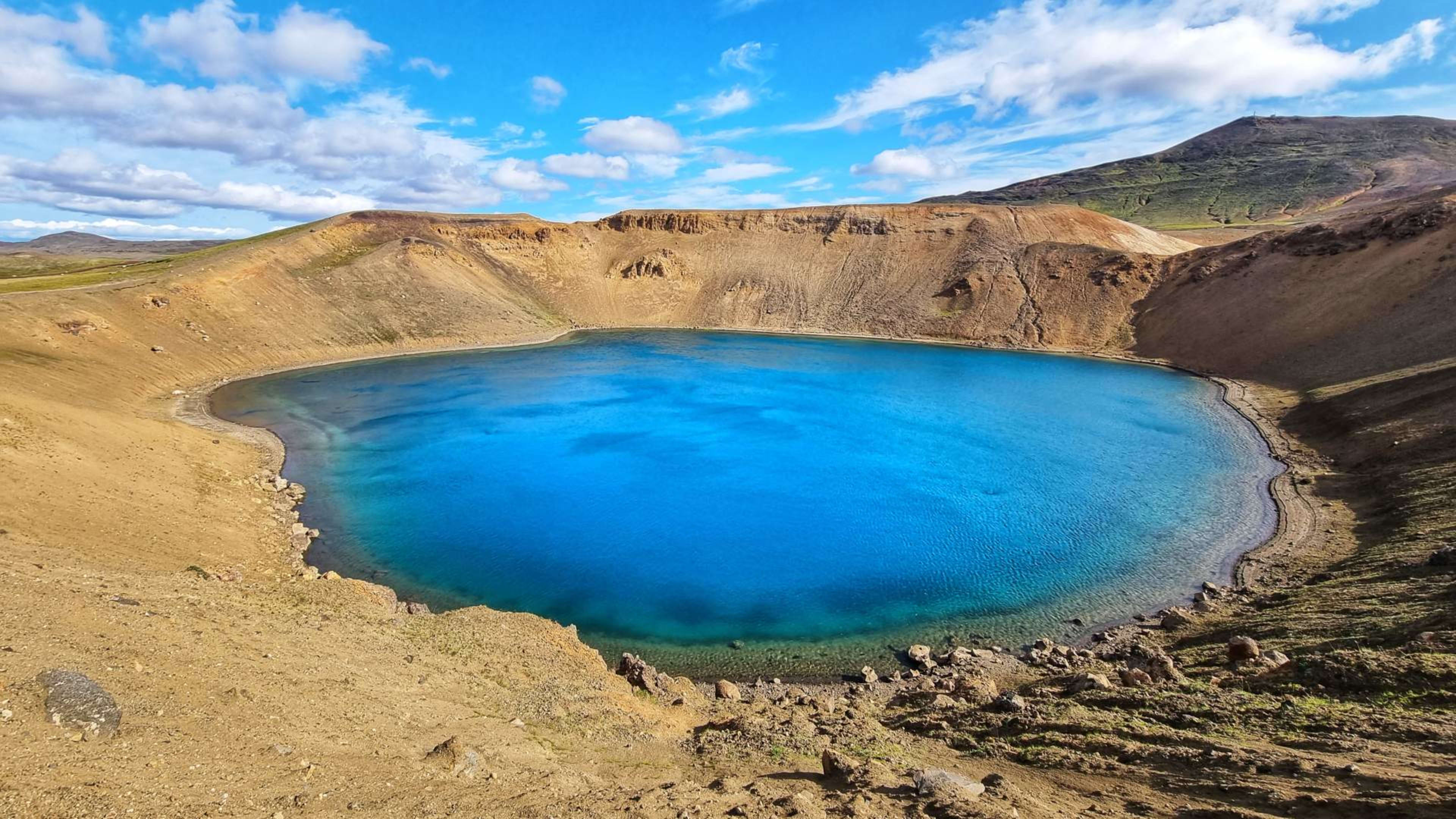
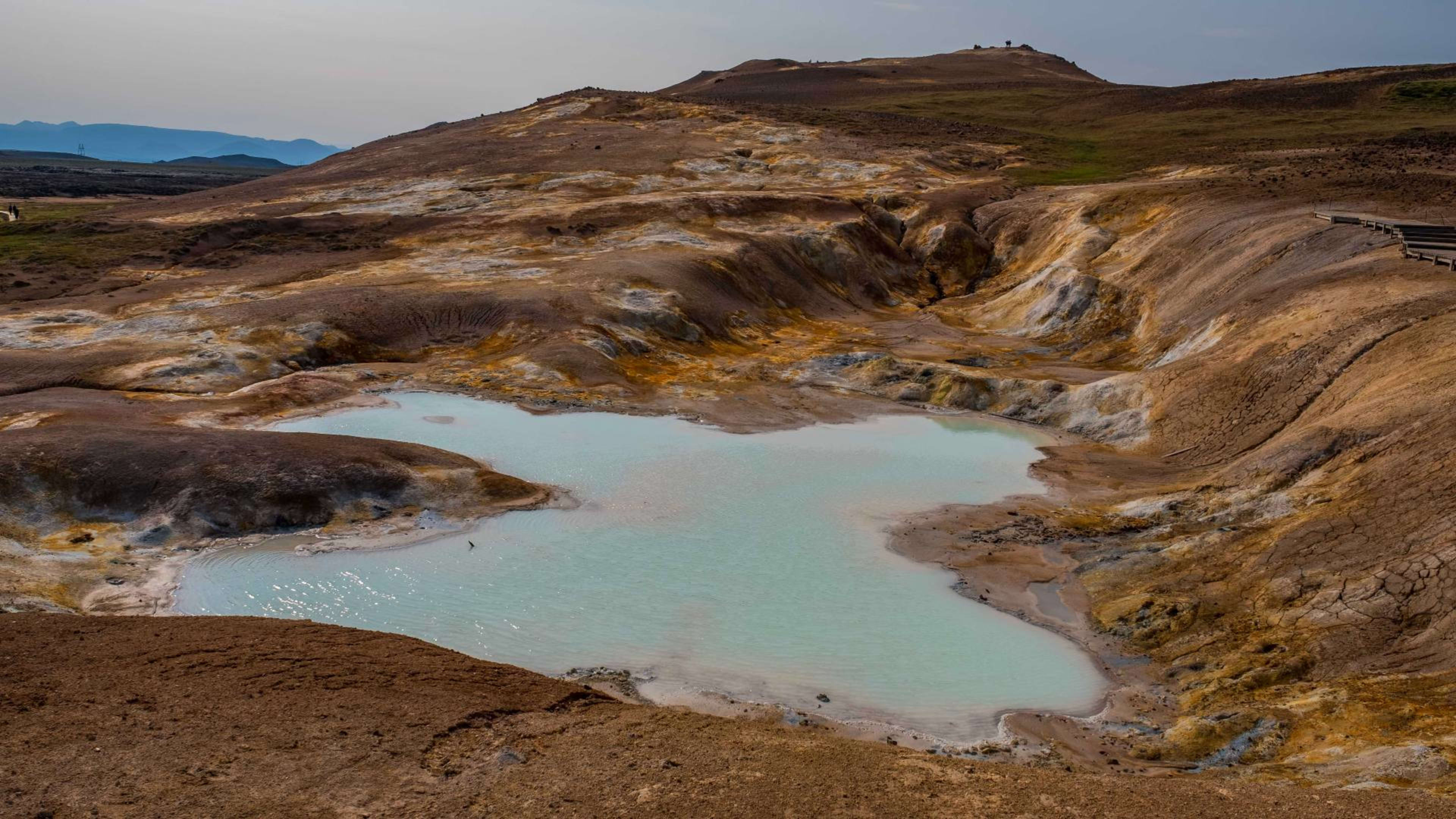
Víti Crater
Víti is an explosion crater on the northern rim of the Krafla caldera, filled with a geothermal lake. It formed during the Mývatn Fires of 1724 to 1729, an earlier eruption episode that reshaped much of the Lake Mývatn area over five years. The lake water varies in colour from pale green to milky turquoise depending on weather conditions, light, and geothermal activity. The crater rim is accessible on foot from the parking area and gives a clear view down into the lake. There is no safe access to the water itself.
The name Víti means hell in Icelandic and was applied to several explosion craters around Iceland, reflecting how these features were interpreted historically.
Getting There and Practical Information
Krafla and Leirhnjúkur are reached by driving north from the Lake Mývatn area through Reykjahlíð village, then taking Route 863 northeast. The drive from Mývatn takes around 30 minutes. The parking area is clearly signposted and serves as the starting point for both the Víti crater walk and the Leirhnjúkur trail. There are no food or drink facilities at the site. Bring water and snacks and dress for wind, as the exposed caldera terrain offers little shelter. Hiking boots with firm soles are recommended given the uneven lava surface.
The area is monitored continuously by the Icelandic Meteorological Office. Access roads are closed if conditions become hazardous. Before visiting, particularly outside of summer, it is worth checking current conditions via the Icelandic Met Office and Safe Travel Iceland.
When to Visit
The site is open year-round but most accessible between May and October. Summer offers the most stable walking conditions and the longest daylight hours. In winter snow can make the lava field trails difficult to follow and conditions on Route 863 can be challenging. The geothermal features are active throughout the year regardless of season, and the contrast between steam rising from the lava field and a snow-covered landscape can make for a striking winter visit for those prepared for the conditions.